Catalog Archive
Auction 113, Lot 862

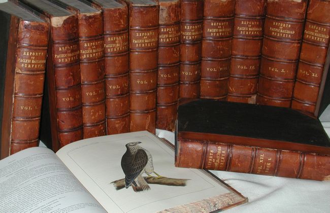
"[Set of 12] Reports of Explorations and Surveys, to Ascertain the Most Practicable and Economical Route for a Railroad from the Mississippi River to the Pacific Ocean…1853-6", U.S. Railroad Surveys
Subject: Exploration and Surveys

Period: 1853-56 (published)

Publication: Senate Ex. Doc. No. 78, 33rd Cong., 2nd Session

Color:

Size:
9 x 11.2 inches
22.9 x 28.4 cm
Download High Resolution Image
(or just click on image to launch the Zoom viewer)

This is the Senate's complete twelve volume set of the monumental railroad survey, including the important Warren Map. Published in 13 quarto volumes (Volume XII has Book I and Book II), all with matching cloth quarter leather and marbled edges. This set is considered by Wagner-Camp as the "cornerstone work in a Western Americana collection and is considered one of the most important works on the Transmississippi West for its published reports on the explorations and the data collected during the surveys." It is becoming very difficult to locate a complete set, let alone one of uniform size and binding. Each volume is signed on the first blank front page, Dennis McCarthy Syracuse. McCarthy was a Republican politician from the state of New York. He was the mayor of Syracuse in 1853, a New York congressman from 1867 to 1871, and a New York senator from 1876 to 1885, in fact, serving as the president pro tempore of that body in 1885. He was the lieutenant governor of New York from 1885 until his death the following year.

In March 1853, Secretary of War, Jefferson Davis, was directed to survey railroad routes to the Pacific per the Army Appropriation Act of that year. Four potential routes were to be explored and surveyed under the supervision of the Topographical Corps.

The governor of Washington Territory, Isaac Ingalls Stevens, directed the northern-most survey between the 47th and 49th parallels. This was the route most favored by Asa Whitney, an early proponent of a transcontinental railroad. Stevens’ reports are contained in Volumes I and XII.

The route along the 38th & 39th parallels was the route advocated by the powerful Senator Thomas Hart Benton. Capt. John W. Gunnison was selected to lead the survey party along what is also known as the Cochetopa Pass route. Gunnison was a surveyor on the Stansbury expedition where he learned the region and developed a good working relationship with Brigham Young and the Mormons. For this reason he was chosen over John C. Fremont who also had knowledge of the area and had lobbied for the job. Indians killed Gunnison and his ill-fated party in the winter of 1853 near the Sevier River in Utah. Lt. Edward G. Beckwith continued Gunnison’s work, traveling north to the 41st parallel and continuing into California. Beckwith wrote the reports for his and Gunnison’s surveys which are contained in Volumes II and X.

The survey along the 35th parallel westward to California was under the command of Capt. Amiel W. Whipple and Lt. Joseph Christmas Ives. This is the route that was favored by Jefferson Davis and was essentially the route traversed by Josiah Gregg in 1839 and later surveyed by Col. John J. Abert. Volumes III, IV, and X contain these reports.

The most southerly survey, which followed the 32nd parallel, was surveyed by Lt. John G. Parke and Capt. John Pope. Parke explored and surveyed from California along the Gila River to the Pima villages and on to the Rio Grande. At the same time, Pope mapped the eastern portion of the route from Dona Ana, New Mexico, to the Red River. The reports for these surveys are in Volumes II, VII, and X.

Jefferson Davis added a fifth survey to locate suitable routes along the Pacific coast and the Sierra Nevada range in order to connect California, Oregon and Washington. These north-south surveys were conducted under the direction of Lt. Robert S. Williamson. His reports are contained in Volumes V, VI, and X.

The surveys demonstrated that a railroad could be built along any one of the routes. This led to political disagreements because the southern routes were objectionable to northern politicians and, of course, the northern routes were objectionable to southern politicians. The Pacific railroad question and resolution stalled over the political wrangling. Through the efforts of Theodore D. Judah, engineer of the Sacramento Valley Railroad, along with Abraham Lincoln’s support, the Railroad Act of 1862 put government support behind the transcontinental railroad. These volumes bring to life the dedication, sacrifice and loss that was finally repaid when, over a decade later, the continent was linked on May 10, 1869 at Promontory Point, Utah.

This complete set is illustrated with hundreds of lithographs, both black and white, tinted and hand colored, and scores of, mostly large folding, maps. The plates include scenery, native inhabitants, flora, fauna, birds, botanical, etc. These reports provide the single most important contemporary source of knowledge of the West. The maps are generally in very good condition. One of the more unimportant profiles is detached and has some fold splits. The Warren map has been torn from the book at the binding edge and into the map. This map's condition is worse than the others, with numerous fold splits and toning. It is complete but in need of conservation.

References: Wheat (TMW) Chapter XXXIV.

Condition: A

Contents tight and generally very good to fine. Covers with some abrasion and wear. Some of leather spine missing in Volumes I, VI, IX, and X with no loss to titling. Contents generally fine with some repairs at binding side.

Estimate: $6,000 - $7,000

Sold for: $7,500

Closed on 12/7/2005

Archived