Catalog Archive
Auction 112, Lot 246

"Plan de la Ville de Boston et ses Environs…", Bellin, Jacques Nicolas

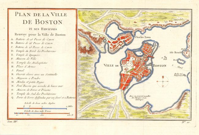
Subject: Colonial Massachusetts - Boston

Period: 1770 (circa)

Publication:

Color: Hand Color

Size:
10.8 x 6.5 inches
27.4 x 16.5 cm
Download High Resolution Image
(or just click on image to launch the Zoom viewer)

Attractive early plan of Boston and the harbor including Charles Town and Isle Ronde. It shows the street plan of the town and wharves, and locates gun batteries, powder magazines, Presbyterian church, prison, town hall, windmill and beacon. Indicates an offshore anchorage and the entrance channel and depicts shoreline topography with the roads running down to the harbor. Large key at left lists sixteen important sites. Engraved at bottom neatline is Tome XIV, No 10. This is very similar to the 1764 Bellin issue from the Petit Atlas Maritime, Tome I, No. 31, but is slightly larger and the title and index are placed on the left. Most likely published in Prevost's l'Histoire des Voyages.

References: cf Tooley (Amer), p.208, #105.

Condition: A

Very nice impression on hand laid paper with full margins. Tiny, nearly invisible, flaw in upper left of chart. Modern coloring with some show through on verso.

Estimate: $325 - $375

Sold for: $350

Closed on 9/28/2005

Archived