Catalog Archive
Auction 111, Lot 131

"Pas-Kaart Vande Zee Kusten inde Boght van Niew Engeland Tusschen de Staaten Hoek en C. de Sable…", Keulen, Johannes van

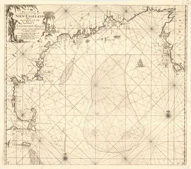
Subject: Colonial New England

Period: 1684 (circa)

Publication: De Niewe Groot Lichtende Zee-Fakkel

Color: Black & White

Size:
23 x 20 inches
58.4 x 50.8 cm
Download High Resolution Image
(or just click on image to launch the Zoom viewer)

This is one of the earliest obtainable sea charts of the New England coast from this famous Dutch pilot book, which was produced during the period of Dutch dominance as a mercantile and shipping power. It covers the coast from Nova Scotia to Cape Cod and Nantucket. The rendering of Cape Cod is very detailed for the period, complete with soundings, shoals and navigational hazards. Offshore the chart is dominated by St. George's Bank - one of the prime cod fisheries of the region. It is embellished with rhumb lines, compass roses, a sailing ship and a large title cartouche featuring natives, a Dutch trader and incongruous palm trees.

References: McCorkle #684.2

Condition: A

Sharp impression and good margins. Bit of faint toning and a couple of insignificant paper flaws, still overall very good and near fine.

Estimate: $3,250 - $4,000

Sold for: $2,000

Closed on 6/8/2005

Archived