Catalog Archive
Auction 109, Lot 57

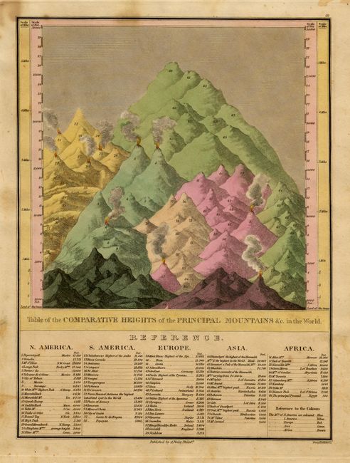
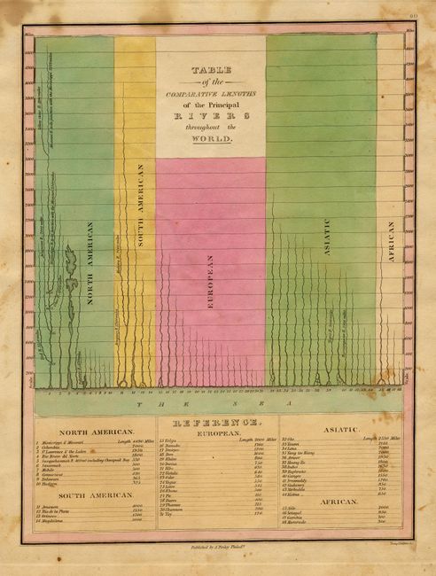
"Table of the Comparative Heights of the Principal Mountains &c. in the World [together with] Table of the Comparative Lengths of the Principal Rivers throughout the World", Finley, Anthony

Subject: Cartographic Miscellany

Period: 1824 (published)

Publication: A New General Atlas

Color: Hand Color

Size:
8.6 x 11.3 inches
21.8 x 28.7 cm
Download High Resolution Image
(or just click on image to launch the Zoom viewer)

Finely's maps employ a delicate and elegant engraving style and provided extensive topographical and watershed information. He was the dominant map maker in the United States in the early 1820s into the 1830s. His atlases were very successful, outselling rival atlases by Carey & Lea, and Tanner. His maps were printed on high quality paper and were routinely corrected and updated.

Two thematic charts that give the relative height of the mountains and the length of the rivers throughout the world. The mountain sheet is a fine perspective of the mountains grouped by height and colored by continent, with a table listing names and elevations and a number key to the perspective. The rivers sheet also groups them by continent. Includes a table at bottom that lists the rivers by name and length with a number key to the chart. Fine engraving by Young & Delleker. A nice pair of early thematic charts.

References:

Condition: B

Fine pastel coloring and impression on thick paper. A few areas of light foxing, else very good.

Estimate: $150 - $200

Sold for: $110

Closed on 12/1/2004

Archived