Catalog Archive
Auction 109, Lot 271

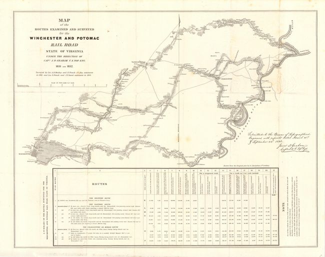
"Map of the Routes examined and surveyed for the Winchester and Potomac Railroad, State of Virginia…", U.S. Corps of Engineers

Subject: Virginia

Period: 1831-32 (dated)

Publication: HR. Doc. 465, 24th Cong., 2nd Sess.

Color: Black & White

Size:
27 x 21 inches
68.6 x 53.3 cm
Download High Resolution Image
(or just click on image to launch the Zoom viewer)

This is one of the earliest printed government surveys drawn from the original plot by Lt. Andrew Atkinson Humphreys. It was based on surveys by Lts. A.D. Mackay and E. French in 1831 and Lts. French and J.F. Izard in 1832. The topographic map illustrates an area between the Shenandoah and Potomac Rivers to Winchester. It shows property owners, mills, distilleries, blacksmith's shops, etc. along the proposed routes. Includes a table at bottom showing a summary of the routes surveyed. The Commonwealth of Virginia was embroiled in controversy over a railway network in the region. The existing transportation system was inefficient for the farmers and iron furnaces in the Shenandoah Valley, but concentrated economic benefits of trade in Virginia and not in neighboring Maryland and Pennsylvania. This line was designed to divert Shenandoah Valley wheat from Alexandria and stimulate growth in Baltimore. Completion of the line in 1836 greatly contributed to the decline of Alexandria.

References: Claussen & Friis #271; Modelski (Railroads) #4.

Condition: B

Issued folding, now backed with archival tissue. A few light foxing spots, one area of creasing, else clean and bright and near fine.

Estimate: $200 - $250

Unsold

Closed on 12/1/2004

Archived