Catalog Archive
Auction 109, Lot 263

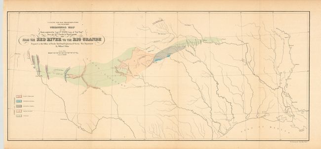
"Geological Map of the Route explored by Capt. Jno. Pope…From the Red River to the Rio Grande…", U.S. War Department

Subject: Texas

Period: 1854 (dated)

Publication: Explorations and Surveys…

Color: Hand Color

Size:
22.7 x 10 inches
57.7 x 25.4 cm
Download High Resolution Image
(or just click on image to launch the Zoom viewer)

During the 1850s, the U.S. government sponsored an extensive series of expeditions designed to gather information on the vast new territories that had been acquired in western North America. The discovery of gold in California further stimulated westward traffic and heightened the need for a faster and more convenient way to bring the far-flung parts of the country together. In 1853 Congress commissioned the Army's Topographic Bureau to conduct a series of surveys to find a suitable route for a transcontinental railroad. There were six major expeditions; five of them covered the area between the Great Plains and west coast, and the sixth explored the coastal states of California and Oregon. All of these expeditions were accompanied by naturalists and artists to document the landscape, flora and fauna along the route. The reports, maps and lithographs were published in the 13 volume report "Explorations and Surveys to ascertain the most practicable and economical route for a Railroad from the Mississippi river to the Pacific Ocean."

A colorful geological map that details the countryside in a band along Capt. Pope's Route from Fort Towson, Oklahoma, to El Paso and Dona Anna on the Rio Grande. Hydrology of the area is well developed. Shows the location of forts and several towns.

References:

Condition: A+

Estimate: $90 - $130

Sold for: $65

Closed on 12/1/2004

Archived