Catalog Archive
Auction 108, Lot 229

"Richardson's New Map of the State of Texas including part of Mexico. Compiled from government surveys and other authentic documents… corrected by H. Wickeland", Desilver, Charles
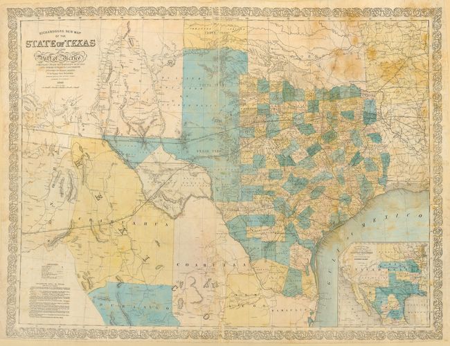
Subject: Texas

Period: 1860 (dated)

Publication: The Texas Almanac

Color: Hand Color

Size:
32 x 24.6 inches
81.3 x 62.5 cm
Download High Resolution Image
(or just click on image to launch the Zoom viewer)

This important antebellum map of Texas was issued for Willard Richardson's Texas Almanac. It provides an up-to-date picture of the state, counties, roads, and mail/stage routes. Railroads completed and in progress are particularly well delineated with a key in the lower left corner listing the completed railroads and their proposed extensions as well as the Galveston Bay and Brazos River canal. In the lower right is a large inset map of the West (including the proposed Arizonia Territory) showing the Proposed Route of the Arkansas Railroad and Proposed R.R. to Guaymas. The topography, coasts and rivers are accurately delineated, with the source being the Topographical Engineers' Map of Texas and part of New Mexico (1857), Pressler's Map of the State of Texas (1858) and Young's Map of the State of Texas, which was published in Desilver's 1859 New Universal Atlas. There were three issues of this map: 1859, 1860 and 1861, each dated as such and issued for the corresponding edition of the Texas Almanac. The almanacs for 1857, and 1862-65 did not contain maps. Two other smaller maps appeared in the Richardson Almanacs: J.H. Young's Map of the State of Texas (from Desilver's atlas) with the 1858 Almanac and Richardson's New Map of Texas, published by Colton (Day #428) in the 1867 Almanac. All these maps were published separately as an option for buyers of the almanac to purchase. Because they were an option, they are seldom found with the almanac and are extremely rare. Most of the maps from the series were sold in Texas. The chaos of the Civil War and frontier times, plus the deleterious climate of Texas on printed materials, resulted in few copies of the maps surviving, and those that survived are in less than fine condition. This map would be a great addition to any serious Texas collection and is well deserving of a professional conservation and preservation effort.

References: Day #1012; cf Phillips (M) p. 846 (1859 & 1861 editions); Rumsey #5178.000 (1861 ed.).

Condition: C

Laid down on mat board. Color slightly faded with some scattered foxing. Fragile paper with minor loss along folds. Please call for a more complete condition description.

Estimate: $2,000 - $3,000

Sold for: $4,750

Closed on 9/29/2004

Archived