Catalog Archive
Auction 107, Lot 161

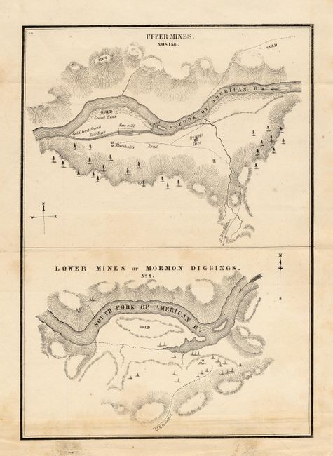
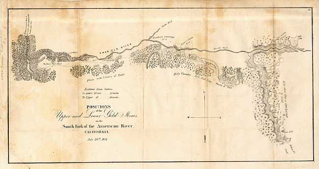
"[Pair] Positions of the Upper and Lower Gold Mines on the South Fork of the American River, California. July 20th, 1848 [together with] Upper Mines & Lower Mines or Mormon Diggings", U.S. Government

Subject: California

Period: 1848 (dated)

Publication: Mason's Report, Doc #1, 30th Congress, 2nd Session

Color: Black & White

Size:
18.4 x 9.3 inches
46.7 x 23.6 cm
Download High Resolution Image
(or just click on image to launch the Zoom viewer)

Pair of the earliest printed maps to actually name and locate gold discoveries in California. Gold was first discovered in January 1848 and Sutter tried in vain to keep the discovery quiet. In July, Col. Mason, the Military Governor of California, toured the diggings and sent a report to the President officially announcing the discovery of gold. These maps were a part of this report, and spawned the great California Gold Rush. The first (18.4 x 9.3") covers the country along the American River from its junction with the Sacramento River to just above Weber's Creek. It shows Sutter's Fort and numerous other diggings. The second map (6.4 x 9") contains two maps within one border. The Upper Mines are along the South Fork of the American River and shows where gold first found by James W. Marshall. The lower map depicts numerous tents surrounding a store with a large area of the bar marked gold. Lt. William T. Sherman, of later Civil War fame, drew the maps when he was adjutant to U.S. Military Gov. Mason.

References: Wheat (Gold) #51 & 52.

Condition: B

Issued folding, now tissue backed. Scattered foxing.

Estimate: $350 - $400

Sold for: $250

Closed on 6/9/2004

Archived