Catalog Archive
Auction 107, Lot 138

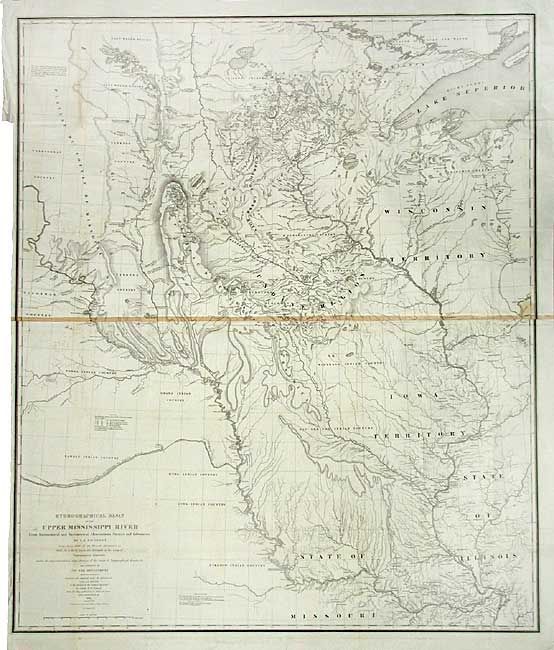
"Hydrographical Basin of the Upper Mississippi River from Astronomical and Barometrical Observations Surveys and Information…", U.S. War Dept.

Subject: United States - Central

Period: 1843 (dated)

Publication: House Doc 52, 28th Congress. 2nd Sess.

Color: Black & White

Size:
30.2 x 36 inches
76.7 x 91.4 cm
Download High Resolution Image
(or just click on image to launch the Zoom viewer)

This extremely important map is the first accurate map of the interior, from St. Louis north to the international boundary. The map was compiled by Lt. W.H. Emory (under the direction of Col. J.J. Albert) from the surveys of J. N. Nicollet, who was assisted by Lt. J.C. Fremont. Thus, bringing together some of the most important names in the history of American mapping in the 19th Century. Nicollet was already a noted French scientist and topographer when he was chosen to lead the expedition during 1838 to 1840. It was the first truly scientific topographical survey of the interior of North America. The map reflects, for the first time, the use of the barometer to obtain elevations and the use of place names on maps based on a systematic analysis of Indian and French place names. Contemporary cartographer, Lt. G.K. Warren, called it, "one of the greatest contributions ever made to American Geography." Litho by C.B. Graham.

References: Claussen & Friis #390; Schwartz and Ehrenberg, p. 267-268, plt. 165.

Condition: B

Brilliant, early impression. Issued folding, now backed with archival tissue. Toned along center where two sheets are joined, rest is quite clean and bright.

Estimate: $400 - $500

Sold for: $550

Closed on 6/9/2004

Archived