Catalog Archive
Auction 105, Lot 72

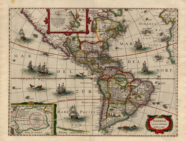
"America noviter delineata", Hondius, Henricus

Subject: Western Hemisphere

Period: 1631 (dated)

Publication:

Color: Hand Color

Size:
19.5 x 14.7 inches
49.5 x 37.3 cm
Download High Resolution Image
(or just click on image to launch the Zoom viewer)

Beautiful map of the Americas originally issued by Jodocus Hondius and derived from two earlier maps by Blaeu. The North Pole depicts Frobisher's theory of the Northwest Passage and the South Pole shows the long-held notion of the mythical southern continent. North America retains the peninsular California and the East Coast is beginning to take shape, although it still lacks detail in the mid-Atlantic region. In South America, there is a large inland sea and two engraved scenes, one of which details a cannibalistic feast. Two stylized insets of the two Polar Regions are enclosed in strapwork cartouches. The map is richly ornamented with a strapwork title cartouche, fleets of ships and sea monsters. State 3 with German text on verso, published between 1633 and 1636, with imprint of Henricus Hondius and 1631 date in cartouche.

References: Burden #192; Goss #27; Tooley (America) plt. 172.

Condition: A

Professional repair in the area just above Terra Incognita. Lovely old color, apparently refreshed. Couple of tape stains in blank margins.

Estimate: $3,000 - $3,500

Sold for: $2,500

Closed on 12/3/2003

Archived