Catalog Archive
Auction 104, Lot 204

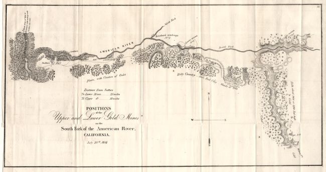
"Positions of the Upper and Lower Gold Mines on the South Fork of the American River, California. July 20th, 1848", Anon.

Subject: California

Period: 1848 (dated)

Publication: Col. Richard b. Mason's Report (HR Doc, No. 1, 30th Congress, Second Session)

Color: Black & White

Size:
18.25 x 9.5 inches
46.4 x 24.1 cm
Download High Resolution Image
(or just click on image to launch the Zoom viewer)

Probably one of the earliest printed maps to actually name and locate gold discoveries in California, and one of the best first-hand accounts of the Gold Rush. It covers the country along the American River from its junction with the Sacramento River to just above Weber’s Creek. It shows Sutter’s Fort and numerous other diggings. Lt. William T. Sherman, of later Civil War fame, drew the map when he was adjutant to U.S. Military Gov. Mason. A most desirable Gold Rush map.

References: Wheat (Gold) #51.

Condition: A

Folding with narrow margin on binding side, as issued. Two small spots, otherwise a fine and very clean example.

Estimate: $200 - $250

Sold for: $275

Closed on 9/10/2003

Archived