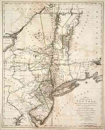
"A Map of the Province of New-York, Reduc'd from the large Drawing of that Province...by Order of His Excellency William Tryon Esqr. Captain General & Governor of the same...to which is added New-Jersey…", Sauthier/Faden
Subject: Colonial Mid Atlantic
Period: 1776 (dated)
Publication:
Color: Hand Color
Size:
22.5 x 28.2 inches
57.2 x 71.6 cm
From actual surveys by Claude Joseph Sauthier, with New Jersey added from the topographical observations of C.J. Sauthier and B. Ratzer. It includes the present states of New York, New Jersey and Vermont with parts of adjoining colonies and Canada. Includes Martha's Vineyard, Long Island, Boston, northern Chesapeake Bay, Annapolis and extends north to show Montreal. A fascinating and detailed look at the towns, villages, military posts and forts, manors, roads, churches, rivers and ferries at the beginning of the Revolutionary War. Locates Dartmouth College and settlements along the Connecticut River. Features the disputed line of partition between New York and New Jersey and early county boundaries in New York.
References: Sellers & Van Ee #1047 (illustrated).
Condition: B
Folding, as issued on thick hand laid paper. Light scattered foxing and light offsetting.