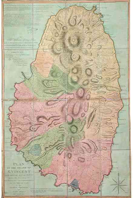
"Plan of the Island of St. Vincent laid Down by Actual Survey under the Direction of the Honorable the Commissioners for the Sale of Lands in the Ceded Islands by John Byres Chief Surveyor 1776", Hooper, Samuel
Subject: St. Vincent
Period: 1776 (dated)
Publication:
Color: Hand Color
Size:
24.2 x 37 inches
61.5 x 94 cm
Large-scale map of St. Vincent dissected into 16 sections and backed with linen as issued. Very detailed plan of the island with individual lots noted from a survey by Byres, William Young, William Hewitt and R. Wynn. Includes a key to leasehold and freehold land, Carib Indian land grants and undisposed Crown lands. Hooper published a series of four large-scale maps of the Ceded Islands, each by John Byres. These included maps of Dominica, Tobago and Bequia plus this example of St. Vincent. These islands were acquired by Britain through the Treaty of Paris that ended the Seven Year's War with France in 1763. The islands were largely uninhabited, so a first priority was to survey and divide so they could be sold to settlers. On this map all of the cultivable land is divided into 149 numbered Freehold and Leasehold tracts. Manuscript notation on parcel #75 names it "Pembroke Estate". Engraved by J. Bayly, London. Extremely scarce, large chart.
References:
Condition: B
Linen backed with some splits on folds, with a little surface soiling and some toning. Couple of old repairs on fold intersections on verso.