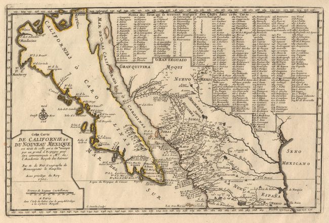
"Cette Carte de Californie et du Nouveau Mexique…", Fer, Nicolas de
Subject: Colonial California and Mexico
Period: 1700 (dated)
Publication: Atlas Curieux
Color: Hand Color
Size:
13.4 x 8.7 inches
34 x 22.1 cm
This small map is very important in the cartographic history of California as an Island. It is one of a few to focus on just California, along with a portion of Mexico. The island is named Californias o Carolinas, as is the sea between the island and the mainland. According to Wagner, this map is the first to show the early discoveries of Father Eusebio Kino and is purported to have been drawn by him in 1696. Numerous place names are introduced for the first time in California including the interestingly titled Ba. d. las 11000 Virgenes. Named in what is now the Southwest part of the United States are Santa Fe, Acoma and Casa Grande. Additionally 314 different places are located and keyed to a table that fills a large portion of the map. This is the important first state.
References: McLaughlin, 134; Tooley (Amer) 62; Wagner 462.
Condition: A+
Crisply engraved with a very nice plate mark and original outline color. One tiny spot at left border and hinge remnants at top margin, still fine.