Catalog Archive
Auction 102, Lot 502

"Carte des Nouvelles Decouvertes au Nord de la Mer du Sud, Tant a l'Est de la Siberie et du Kamchatka, qu'a l'Ouest de la Nouvelle France", Delisle/Buache

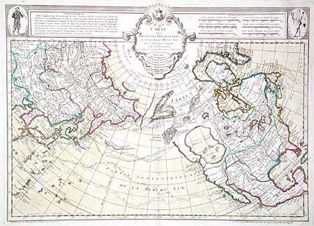
Subject: North Pacific, Alaska and Pacific Northwest

Period: 1780 (circa)

Publication:

Color: Hand Color

Size:
25.2 x 17.8 inches
64 x 45.2 cm
Download High Resolution Image
(or just click on image to launch the Zoom viewer)

This is Dezauche's reissue of Joseph Nicolas Delisle and Philippe Buache's rare 1750 map of the North Pacific. It is a cornerstone map of Alaska and the Pacific Northwest showing the discoveries of the Russians in 1723, 1732 and 1741, the tracks of Bering's first and second voyages, Delisle's voyage with Capt. Tchirikow in 1741, the track of De Frondat's voyage of 1709, and the route of the Galleons in 1743. The west coast of North America is entirely fictitious north of Cap Blanc with an enormous Sea of the West, Lac Valasco, Isle of Bernarda. A network of rivers and lakes making up most of a Northwest Passage is derived from the apocryphal voyages of the Spanish admiral Bartholome de Fonte. Title in rococo cartouche flanked by a native of Kamchatka in upper left corner and a native of Louisiana in upper right corner.

References: Tooley (America) p. 35 #105, plt. #22; Wagner #566.

Condition: A+

Some faint damp stains in blank margins, well away from map. Overall a very fine example. Remnants of linen hinge tape on verso.

Estimate: $2,400 - $2,750

Unsold

Closed on 3/5/2003

Archived