Catalog Archive
Auction 102, Lot 177

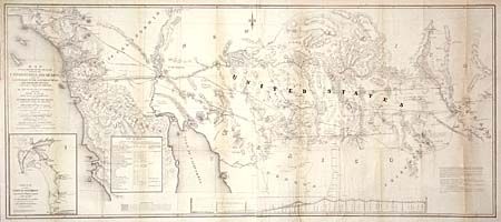
"Map of that Portion of the Boundary between the United States and Mexico, from the Pacific Coast to the Junction of the Gila and Colorado Rivers...and The Rio Gila from Near its Intersection with the Southern Boundary of New Mexico…", Gray, Andrew B.
Subject: Southwestern United States & Mexico

Period: 1855 (dated)

Publication: Senate Doc. #55, 33rd Cong., 2nd Sess.

Color: Black & White

Size:
49 x 21 inches
124.5 x 53.3 cm
Download High Resolution Image
(or just click on image to launch the Zoom viewer)

Surveyed Under the Direction of Hon. John B. Wheeler U.S. Commissioner, this large and elaborate map was deemed by Wheat to be "clearly a major performance." It encompasses all of the decisions of the Joint Commission (Treaty of Guadeloupe Hidalgo) and shows the territory acquired under the Gadsden Purchase in 1854. Full of interesting detail between the 30th and 34th parallels, stretching from the Pacific Ocean to Texas, and includes as an inset "Sketch of the Port of San Diego." A rare sheet by Andrew B. Gray published in his "Report ... Relative to the Mexican Boundary".

References: Wheat (TMW) #840.

Condition: A

Lightly toned along folds. Backed with archival tissue.

Estimate: $300 - $400

Sold for: $550

Closed on 3/5/2003

Archived