Catalog Archive
Auction 102, Lot 148
"Map of United States Military Rail Roads, Showing the Rail Roads Operated during the War from 1862-1866, as Military Lines under the Direction of Bvt. Brig. Gen. B.C. McCallum, Director and General Manager", U.S. War Department
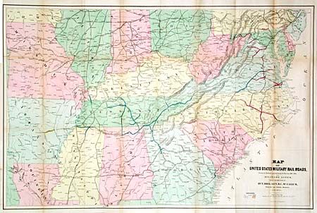
Subject: Southcentral United States
Period: 1866 (dated)
Publication:
Color: Hand Color
Size:
38.2 x 25 inches
97 x 63.5 cm
Download High Resolution Image
(or just click on image to launch the Zoom viewer)
(or just click on image to launch the Zoom viewer)