Catalog Archive
Auction 102, Lot 108

"A Map of the Eastern Part of the Province of New York with Part of New Jersey, &c. Drawn from the best Authorities", Kitchin, Thomas

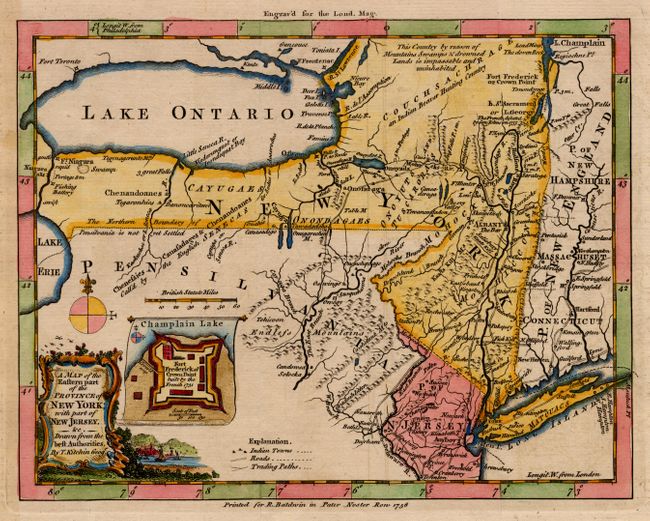
Subject: Colonial Mid-Atlantic

Period: 1756 (published)

Publication: London Magazine

Color: Hand Color

Size:
8.5 x 6.5 inches
21.6 x 16.5 cm
Download High Resolution Image
(or just click on image to launch the Zoom viewer)

Interesting, small map depicting the main theater of the French and Indian War during the first year of the conflict. The region depicted includes the Hudson River valley, north to Lake Champlain, including Forts Ticonderoga and Frederick. Also shown are the Mohawk River and the waterways from the upper Hudson to Lake Ontario. The western parts of the New England states are shown, as is northern New Jersey, and northeastern Pennsylvania. The border between New York and Pennsylvania is shown considerably north of the present-day boundary. A note states that Pensilvania is not yet settled with much of the region labeled the Endless Mountains. Indian tribal and hunting lands are noted, as well as roads and Trading Paths. Inset is a tiny plan of Fort Frederick at Crown Point, with its own tiny compass rose and scale of feet. This important French fort had been captured by the British the previous year. Decorative landscape cartouche and delicate compass rose embellish the map.

References: Sellers & van Ee #1038; Jolly-LOND #109.

Condition: A

Nice, crisp engraving. Tiny separation in upper blank margin, faint toning and offsetting.

Estimate: $375 - $475

Sold for: $425

Closed on 3/5/2003

Archived