Catalog Archive
Auction 102, Lot 102

"Carte de la Nouvelle France, ou se voit le cours des Grandes Rivieres de S. Laurens & de Mississipi, Aujour d'hui S. Louis…", Ottens/De Fer

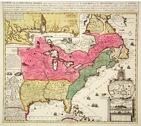
Subject: Colonial North America

Period: 1720 (circa)

Publication:

Color: Hand Color

Size:
21.5 x 18 inches
54.6 x 45.7 cm
Download High Resolution Image
(or just click on image to launch the Zoom viewer)

This is the Ottens reduced version of Nicolas de Fer's important map of 1718. It is a very handsome map and represents the most informative map of the French possessions in North America in the early 18th century. Inset with a very decorative cartouche style plan and view of Quebec City (uncolored). Louisiana and the Mississippi valley are based on Delisle's manuscript map of 1701. The geography of New England and Eastern Canada originates with Franquelin. Inset at top left is a large-scale map of the Mississippi delta and Mobile Bay based on the voyage of Pierre Le Moyne d'Iberville. The map is filled with wildlife, scenes of Indians hunting, Indian villages and notations, and the oceans are embellished with numerous ships, canoes and sea monsters.

References: Kershaw #336; McCorkle #719.5.

Condition: B

Top margin trimmed affecting neatline of title. Old paper repairs at top and bottom fold, not affecting map image. Overall a very fine impression with bold original color.

Estimate: $2,750 - $3,250

Unsold

Closed on 3/5/2003

Archived