Catalog Archive
Auction 101, Lot 175

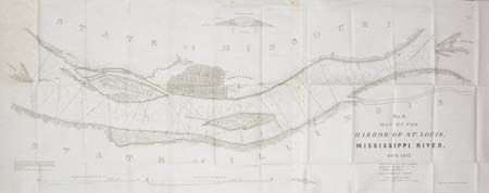
"No.3. Map of the Harbor of St. Louis, Mississippi River. Oct. 1837", Lee, Robert E.
Subject: Illinois

Period: 1837 (dated)

Publication: Ex Senate doc 139. 25th congress 2nd Session

Color: Black & White

Size:
41 x 16 inches
104.1 x 40.6 cm
Download High Resolution Image
(or just click on image to launch the Zoom viewer)

Surveyed by Lt. R.E. Lee. Shows a street plan (with some streets named) of St. Louis, stone quarries, lime kilns, Indian mounds, etc. Includes the islands of Cascarot (partial), Bloody, Duncan's and part of Cahoe. Details proposed dikes and revetments to improve the harbor including a cross-section of a typical dyke. Finely drawn with incredible detail.

References: Koepp #316.

Condition: A

Folding, as issued. Foxed at first panel fold and along top, still very good.

Estimate: $150 - $200

Sold for: $150

Closed on 12/4/2002

Archived