Catalog Archive
Auction 100, Lot 92

"Carte Physique et Politique de l'Amerique Septentrionale…", Brue, Adrien Hubert

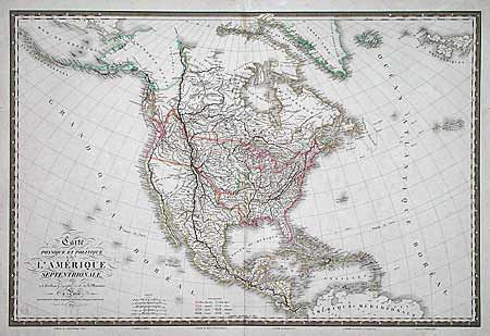
Subject: North America

Period: 1821 (dated)

Publication:

Color: Hand Color

Size:
33.8 x 22.5 inches
85.9 x 57.2 cm
Download High Resolution Image
(or just click on image to launch the Zoom viewer)

Huge map of North America and the Caribbean showing the political divisions and colonial possessions with a color key at bottom. Brue prepared the maps for Louis de Onis's "Memoir upon the Negotiations between Spain and the United States which led to the Treaty of 1819" and this map reflects the careful details characteristic of his work. The boundary between the U.S. and Canada reflect American interests into British Columbia. Large Arkansas Territory and early borders for Missouri are depicted. In the West, an interesting novelty is shown with L. Timpanagos, L. Teguayo ou Sale, and R. S. Philippe ou del Colorado connected by a dotted line and providing a river passage to the Pacific. Keyboard style border surround the extremely handsome map. Published by J. Goujon with his blind stamp below cartouche.

References:

Condition: A

Well-repaired tear just entered top border, else very fine.

Estimate: $800 - $1,000

Sold for: $1,000

Closed on 9/12/2002

Archived