Catalog Archive
Auction 100, Lot 253

"Mapa Geografico de America Meridional, Dispuesto Y Gravado Por D. Juan de la Cruz Cano y Olmedilla…", Cruz Cano y Olmedilla, Juan de la

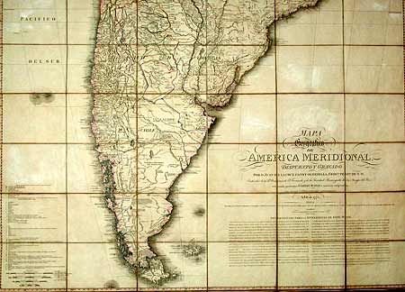
Subject: South America

Period: 1799 (dated)

Publication:

Color: Hand Color

Size:
51.3 x 72.5 inches
130.3 x 184.2 cm
Download High Resolution Image
(or just click on image to launch the Zoom viewer)

This remarkable map was drawn by Juan de Cruz Cano y Olmedilla under the direction of the Spanish government and is based on cartographic material of Consejo de Indias, Jose de Ayala and the reports of Jesuits. The purpose of the map was to delineate the boundary between Spanish and Portuguese colonies. It was first completed in 1775 and revised in 1776 a number of times in order to satisfy the Spanish officials. The map is by far the most precise and complete map of South America and considerably more accurate than any map of North America from this period. It was used in several treaty negotiations during the 19th century, particularly between Brazil and Argentina in 1894. Thus, it can be compared to John Mitchell's landmark map of North America. This is the re-issue of the 3rd edition by William Faden. All issues are extremely rare. Dissected and laid on original linen, in two sections.

References: Imagio Mundi XX, p. 49-78; Phillips (M) p. 802.

Condition: B

Mild toning, foxing and a bit of faint offsetting, else very good.

Estimate: $3,500 - $4,500

Sold for: $2,500

Closed on 9/12/2002

Archived