Showing Featured Lots(remove filter)
Showing Unsold Lots(remove filter)
Current Auction
28 lots
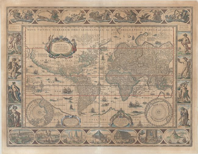
Lot 2
Subject: World
Blaeu, Willem
Nova Totius Terrarum Orbis Geographica ac Hydrographica Tabula, 1635
Size: 21.3 x 16.1 inches (54.1 x 40.9 cm)
Estimate: $10,000 - $12,000
Blaeu's Magnificent Carte-a-Figures World Map
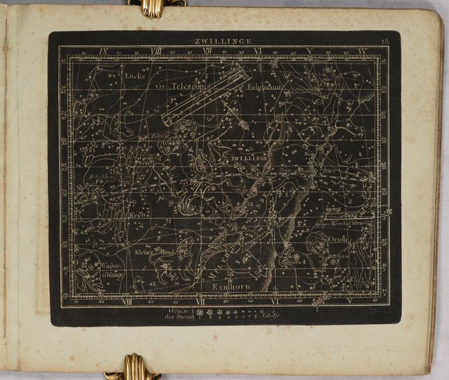
Lot 37
Subject: Celestial Atlas
Goldbach, Christian Friedrich
Neuester Himmels-Atlas zum Gebrauche sur Schul- und Akademischen Unterricht, nach Flamsteed, Bradley, Tob. Mayer, De la Caille, Le Francais de la Lande und v. Zach..., 1803
Size: 11.5 x 10 inches (29.2 x 25.4 cm)
Estimate: $2,000 - $2,400
Unique Celestial Atlas with Stars in Relief Against a Black Sky

Lot 52
Subject: Cartographic Miscellany, Internet
Road Map to the World Wide Web - The World Wide Web Business and Beyond, 1995
Size: 36.5 x 24 inches (92.7 x 61 cm)
Estimate: $2,000 - $2,300
Scarce Map of the Early World Wide Web
Lot 55
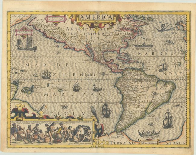
Subject: Western Hemisphere - America
Hondius, Jodocus
America, 1606
Size: 19.6 x 14.7 inches (49.8 x 37.3 cm)
Estimate: $4,500 - $5,500
Hondius' Important Map of the Americas
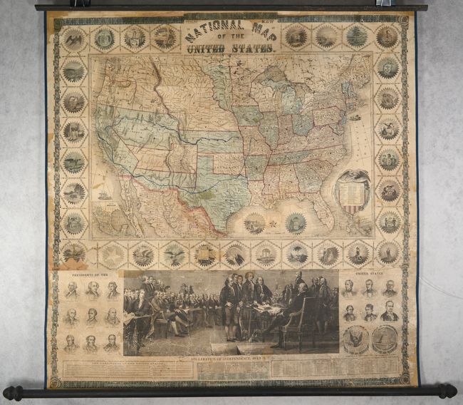
Lot 117
Subject: United States
Phelps & Watson
Phelps' New National Map of the United States, 1859
Size: 36.5 x 37.8 inches (92.7 x 96 cm)
Estimate: $2,200 - $2,500
Attractive Wall Map Issued at the Onset of the Civil War
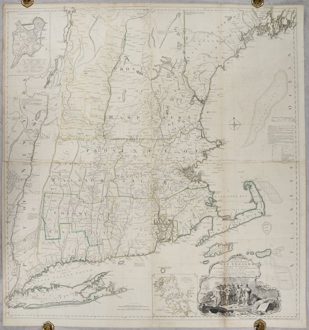
Lot 145
Subject: Colonial New England United States
Jefferys, Thomas
A Map of the Most Inhabited Part of New England, Containing the Provinces of Massachusets Bay and New Hampshire, with the Colonies of Conecticut and Rhode Island..., 1755
Size: 39.1 x 40.8 inches (99.3 x 103.6 cm)
Estimate: $4,750 - $6,000
Rare State of Jefferys' Influential Map of New England in Contemporary Color
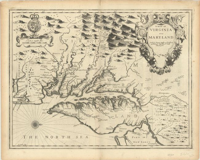
Lot 148
Subject: Colonial Mid-Atlantic United States
Speed/Lamb
A Map of Virginia and Maryland, 1676
Size: 19.6 x 14.9 inches (49.8 x 37.8 cm)
Estimate: $4,000 - $4,750
The First Printed Map to Draw Upon the Legendary Herrman Map of the Chesapeake Bay
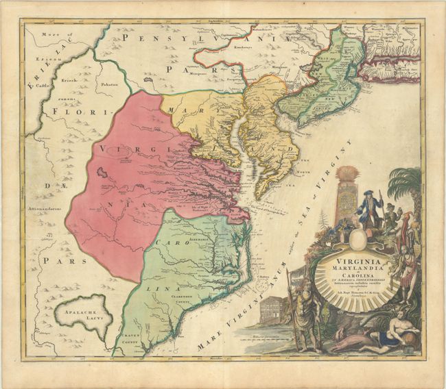
Lot 149
Subject: Colonial Mid-Atlantic United States
Homann, Johann Baptist
Virginia Marylandia et Carolina in America Septentrionali Britannorum Industria Excultae, 1720
Size: 22.8 x 19.3 inches (57.9 x 49 cm)
Estimate: $1,400 - $1,700
Map Created to Promote German Immigration to the New World
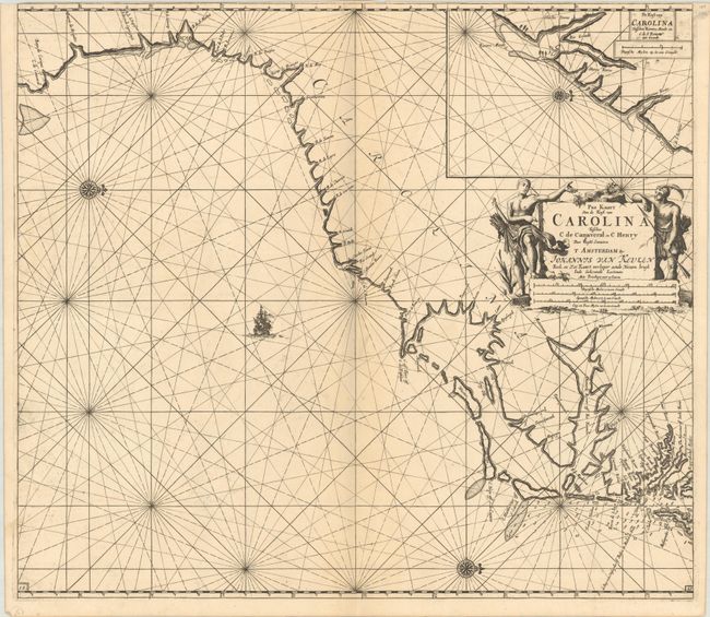
Lot 155
Subject: Colonial Southeastern United States
Keulen, Johannes van
Pas Kaart van de Kust van Carolina Tusschen C de Canaveral en C Henry, 1702
Size: 23 x 20.3 inches (58.4 x 51.6 cm)
Estimate: $2,400 - $3,000
Dutch Chart of the Carolinas
Lot 157
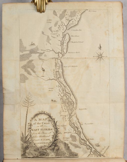
Subject: Southeastern United States
Bartram, William
Travels Through North & South Carolina, Georgia, East & West Florida, the Cherokee Country, the Extensive Territories of the Muscogulges, or Creek Confederacy, and the Country of the Chactaws..., 1791
Size: 5.9 x 9.8 inches (15 x 24.9 cm)
Estimate: $10,000 - $12,000
Complete First Edition of Bartram's Work on the American Southeast
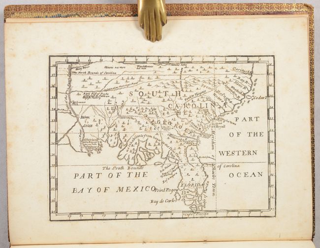
Lot 162
Subject: Colonial Southern United States
[Map in Book] [New Map of Georgia] [in] Reasons for Establishing the Colony of Georgia, with Regard to the Trade of Great Britain..., 1733
Size: 7.3 x 5.3 inches (18.5 x 13.5 cm)
Estimate: $5,500 - $6,500
First Printed Map to Name Georgia
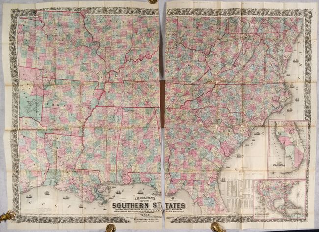
Lot 166
Subject: Southern United States, Civil War
Colton, Joseph Hutchins
J.H. Colton's Map of the Southern States. Maryland, Delaware, Virginia, Kentucky, Tennessee, Missouri, North Carolina, South Carolina, Georgia, Alabama, Mississippi, Arkansas, Louisiana and Texas..., 1864
Size: 52.7 x 38 inches (133.9 x 96.5 cm)
Estimate: $2,500 - $3,250
Large-Scale Map of the South Issued During the Civil War
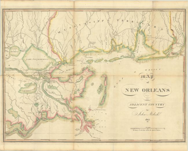
Lot 170
Subject: Louisiana & Mississippi
Melish, John
Map of New Orleans and Adjacent Country, 1815
Size: 21 x 15.4 inches (53.3 x 39.1 cm)
Estimate: $3,500 - $4,500
Scarce War of 1812 Map Highlighting the Gulf Theater of War
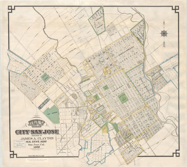
Lot 203
Subject: San Jose, California
Britton & Rey
Map of the City of San Jose, 1886
Size: 37.2 x 35 inches (94.5 x 88.9 cm)
Estimate: $2,000 - $2,500
An Early Large-Format Map of San Jose
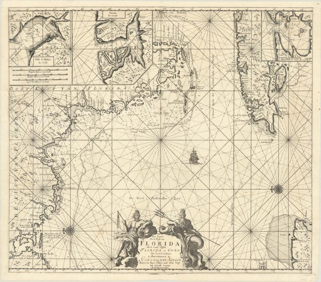
Lot 226
Subject: Western Florida & Cuba
Keulen, Gerard van
Pas Kaart van de Boght van Florida met de Canaal Tusschen Florida en Cuba , 1734
Size: 22.8 x 20.1 inches (57.9 x 51.1 cm)
Estimate: $2,400 - $3,000
One of the First Charts of the Florida Gulf Coast
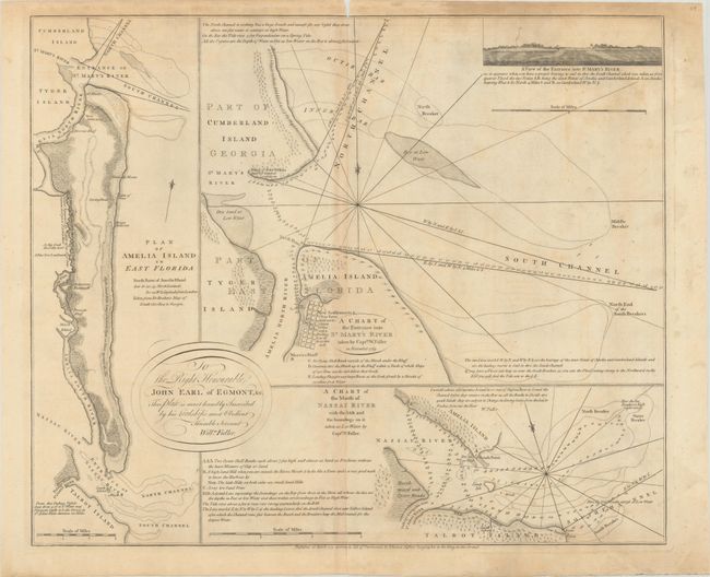
Lot 228
Subject: Amelia Island, Florida
Jefferys, Thomas
A Chart of the Entrance into St. Mary's River Taken by Captn. W. Fuller in November 1769 [on sheet with] Plan of Amelia Island in East Florida [and] A Chart of the Mouth of Nassau River... , 1770
Size: 24.1 x 20 inches (61.2 x 50.8 cm)
Estimate: $3,000 - $3,750
Important Charts Detailing Amelia Island and Surrounding Rivers
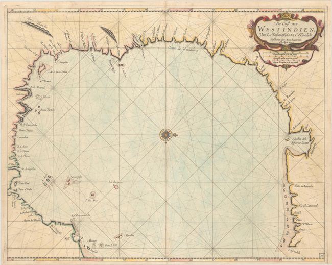
Lot 327
Subject: Western Gulf of Mexico, Texas
Roggeveen, Arent
De Cust van Westindien, van la Desconoscida, tot C. Escondido, 1680
Size: 20.3 x 16.2 inches (51.6 x 41.1 cm)
Estimate: $11,000 - $14,000
"The Most Detailed Chart of the Present-Day Texan Coastline" - Burden
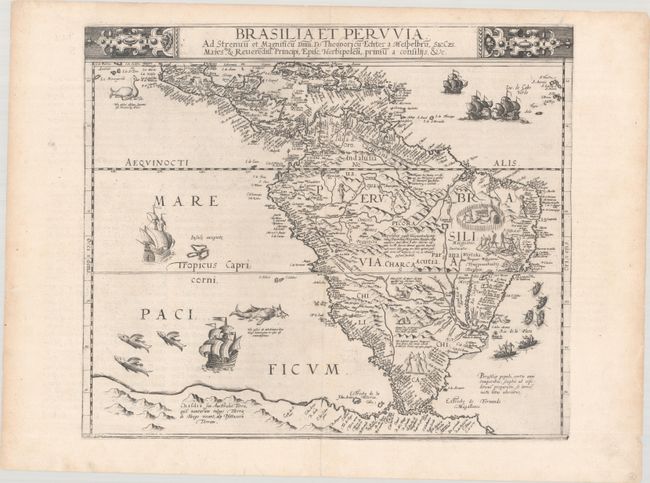
Lot 357
Subject: South America
Jode, Cornelis de
Brasilia et Peruvia ad Strenuu et Magnificu Dnm. D. Theodoricu Echter..., 1593
Size: 16.6 x 14.1 inches (42.2 x 35.8 cm)
Estimate: $9,500 - $12,000
One of the Earliest Maps of the South American Continent
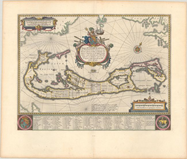
Lot 395
Subject: Bermuda
Blaeu, Willem
Mappa Aestivarum Insularum, Alias Barmudas Dictarum, ad Ostia Mexicani Aestuary..., 1642
Size: 21 x 15.9 inches (53.3 x 40.4 cm)
Estimate: $1,600 - $1,900
Map of Bermuda Based on Richard Norwood's Famous Survey in Full Contemporary Color
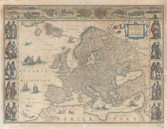
Lot 406
Subject: Europe
Blaeu, Willem
Europa Recens Descripta, 1635
Size: 21.9 x 16.1 inches (55.6 x 40.9 cm)
Estimate: $3,000 - $3,750
Blaeu's Carte-a-Figures Map of Europe
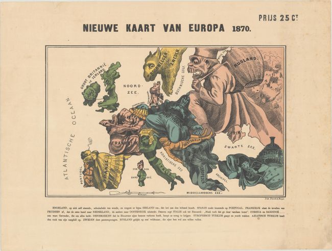
Lot 411
Subject: Europe, War
Emrik & Binger
[Lot of 2] Nieuwe Kaart van Europa 1870 [and] Humoristische Kaart van Europa 1870, 1870
Size: 15.4 x 9.8 inches (39.1 x 24.9 cm)
Estimate: $1,400 - $1,700
Pair of Satirical Dutch Maps Showing Contrasting Views at the Outset of the Franco-Prussian War
Lot 417
Subject: European Countries
Aleph
Geographical Fun: Being Humorous Outlines of Various Countries. With an Introduction and Descriptive Lines, 1869
Size: 9.3 x 11.1 inches (23.6 x 28.2 cm)
Estimate: $2,000 - $2,500
Book with 12 Satirical Maps of European Countries
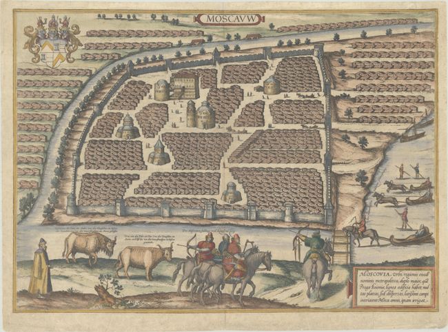
Lot 557
Subject: Moscow, Russia
Braun & Hogenberg
Moscauw, 1597
Size: 19.3 x 13.8 inches (49 x 35.1 cm)
Estimate: $2,200 - $2,500
Braun & Hogenberg's First Plan of Moscow
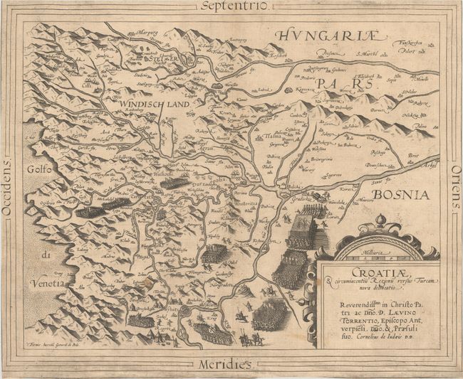
Lot 566
Subject: Croatia
Jode, Cornelis de
Croatiae, & Circumiacentiu Regionu Versus Turcam Nova Delineatio, 1593
Size: 15.6 x 12.9 inches (39.6 x 32.8 cm)
Estimate: $1,100 - $1,400
Rare Map of Croatia During Long Turkish War
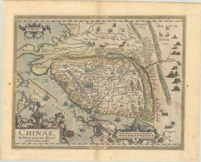
Lot 641
Subject: China
Ortelius, Abraham
Chinae, olim Sinarum Regionis, Nova Descriptio. Auctore Ludovico Georgio, 1584
Size: 18.4 x 14.5 inches (46.7 x 36.8 cm)
Estimate: $4,000 - $4,750
The First European-Printed Map of China
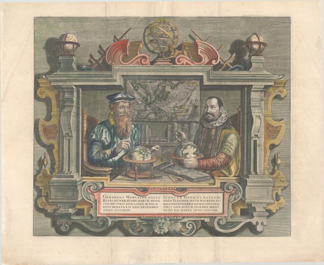
Lot 713
Subject: Portrait
Hondius
Gerardus Mercator... Iudocus Hondius..., 1619
Size: 17.8 x 15.1 inches (45.2 x 38.4 cm)
Estimate: $1,000 - $1,300
Famous Portraits of Mercator and Jodocus Hondius
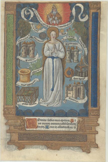
Lot 748
Subject: Early Printing
Hardouin, Gilles
[Book of Hours Leaf], 1520
Size: 5.8 x 8.8 inches (14.7 x 22.4 cm)
Estimate: $1,000 - $1,300
Superb Image of the Immaculate Conception of Mary in Contemporary Hand Color with Gilt Highlights
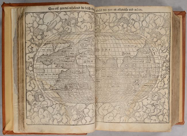
Lot 756
Subject: Atlases
Munster, Sebastian
[Cosmographey oder Beschreibung aller Länder], 1567
Size: 8.8 x 12.5 inches (22.4 x 31.8 cm)
Estimate: $12,000 - $15,000
Superbly Bound Edition of Cosmographia with 115 Maps & Views
28 lots