Showing No Reserve Lots(remove filter)
Showing results for:Auction 96
Catalog Archive
48 lots
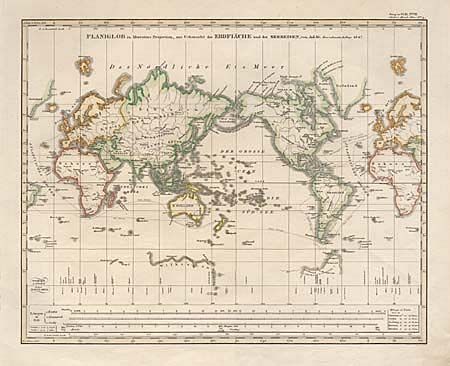
Auction 96, Lot 40
Subject: World
Stieler, Adolph
Planiglob in Mercators Projection, zur Uebersicht der Erdfläche und der Seereisen, von Ad. St., 1847
Size: 14.5 x 11.5 inches (36.8 x 29.2 cm)
Estimate: $60 - $80
Sold for: $0
Closed on 9/12/2001
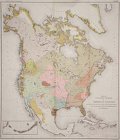
Auction 96, Lot 97
Subject: North America
Powell, John Wesley
Map of Linguistic Stocks of American Indians chiefly within the Present Limits of the United States, 1890
Size: 17.5 x 20.3 inches (44.5 x 51.6 cm)
Estimate: $200 - $250
Sold for: $325
Closed on 9/12/2001
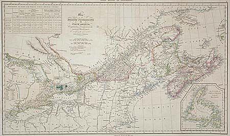
Auction 96, Lot 127
Subject: Canada
Arrowsmith, Aaron, Sr.
Map of the British Possessions in North America, Compiled from Documents in the Colonial Department. To accompany the report of the Emigration Committee, 1828
Size: 26.2 x 15.5 inches (66.5 x 39.4 cm)
Estimate: $250 - $300
Sold for: $240
Closed on 9/12/2001
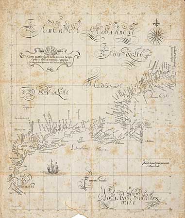
Auction 96, Lot 130
Subject: New England
Dudley, Robert (Sir)
Carta particolare della nuoa Belgia e parte della nuoua Anglia, 1850
Size: 14 x 17.5 inches (35.6 x 44.5 cm)
Estimate: $50 - $70
Sold for: $25
Closed on 9/12/2001
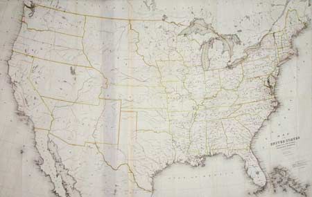
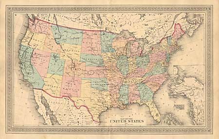
Auction 96, Lot 133
Subject: United States
Burr, David H.
Map of the United States exhibiting the several Collection Districts, 1856
Size: 49.3 x 31.2 inches (125.2 x 79.2 cm)
Estimate: $400 - $600
Sold for: $900
Closed on 9/12/2001
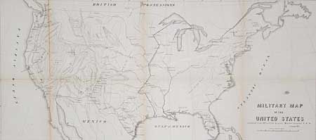
Auction 96, Lot 134
Subject: United States
U.S. War Dept.
Military map of the United States, 1857
Size: 30 x 13.5 inches (76.2 x 34.3 cm)
Estimate: $100 - $150
Sold for: $160
Closed on 9/12/2001
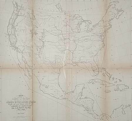
Auction 96, Lot 135
Subject: United States
U.S. War Department
Map Exhibiting the Lines of March passed over by troops of the United States during the year ending June 30th, 1858, 1858
Size: 18.8 x 17.3 inches (47.8 x 43.9 cm)
Estimate: $80 - $100
Sold for: $75
Closed on 9/12/2001
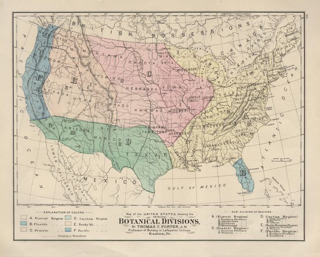
Auction 96, Lot 137
Subject: United States
Gray, O. W.
Map of the United States showing the Botanical Divisions, 1873
Size: 15 x 11.7 inches (38.1 x 29.7 cm)
Estimate: $45 - $55
Sold for: $80
Closed on 9/12/2001
Auction 96, Lot 138
Subject: United States
Anon.
Map of the United States, 1874
Size: 23.5 x 14.5 inches (59.7 x 36.8 cm)
Estimate: $50 - $60
Sold for: $55
Closed on 9/12/2001
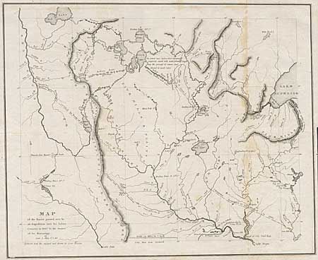
Auction 96, Lot 146
Subject: Central United States
Allen, James (Lt.)
Map of the Route Passed over by an Expedition into the Indian Country in 1832 to the Source of the Mississippi, 1834
Size: 19 x 15.5 inches (48.3 x 39.4 cm)
Estimate: $300 - $350
Sold for: $300
Closed on 9/12/2001
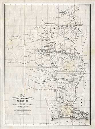
Auction 96, Lot 147
Subject: Central United States
Poinsett, J. R.
Map Illustrating the plan of the defences of the Western & North-Western Frontier, as proposed by the Hon: J.R. Poinsett, Sec. of War, in his report of Dec. 30, 1837, 1837
Size: 15.5 x 21.5 inches (39.4 x 54.6 cm)
Estimate: $450 - $550
Sold for: $250
Closed on 9/12/2001
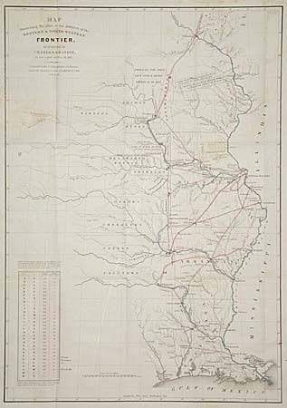
Auction 96, Lot 148
Subject: Central United States
Gratiot, Charles
Map Illustrating the Plan of the Defences of the Western & North-Western Frontier, as proposed by Charles Gratiot, in his report of Oct. 31, 1837, 1838
Size: 15.2 x 21.5 inches (38.6 x 54.6 cm)
Estimate: $450 - $550
Sold for: $250
Closed on 9/12/2001
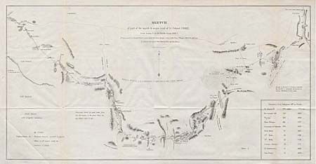
Auction 96, Lot 150
Subject: Western United States
U.S. War Dept.
Sketch of part of the march & wagon road of Lt. Colonel Cooke, from Santa Fe to the Pacific Ocean 1846-47, 1847
Size: 22.8 x 11.6 inches (57.9 x 29.5 cm)
Estimate: $200 - $250
Sold for: $200
Closed on 9/12/2001
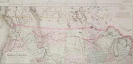
Auction 96, Lot 151
Subject: Western United States
Colton, G.W. & C.B.
Map of the country from Lake Superior to the Pacific Ocean. From the latest Explorations and Surveys to accompany the report of Edwin F. Johnson Chf. Engr. Northern Pacific RR., 1867
Size: 44.5 x 21.8 inches (113 x 55.4 cm)
Estimate: $600 - $800
Sold for: $550
Closed on 9/12/2001
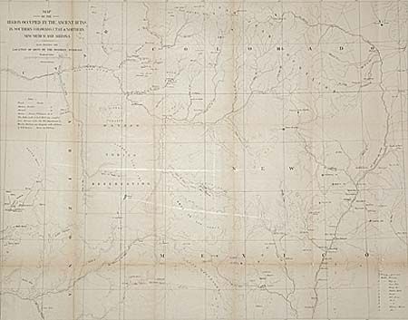
Auction 96, Lot 152
Subject: Southwestern United States
Wheeler, George (Lt)
Map of the Region Occupied by the Ancient Ruins in Southern Colorado, Utah and Northern New Mexico and Arizona Also Showing the Locations of Most of the Modern Pueblos, 1876
Size: 24.5 x 19.1 inches (62.2 x 48.5 cm)
Estimate: $75 - $100
Sold for: $70
Closed on 9/12/2001
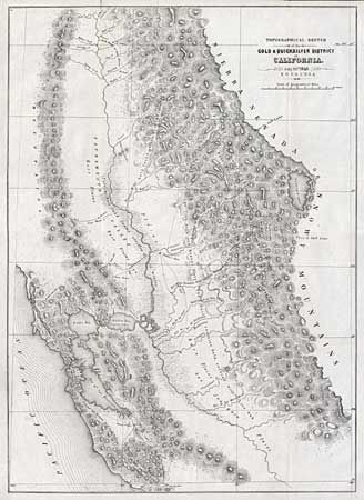
Auction 96, Lot 154
Subject: California
Ord, E. O. C.
Topographical Sketch of the Gold & Quicksilver District of California, 1848
Size: 15.5 x 21.5 inches (39.4 x 54.6 cm)
Estimate: $400 - $500
Sold for: $550
Closed on 9/12/2001
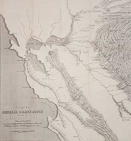
Auction 96, Lot 155
Subject: California
Derby, George Horatio (Lt)
Sketch of General Riley's Route Through the Mining Districts July and Aug. 1849, 1850
Size: 19.8 x 21 inches (50.3 x 53.3 cm)
Estimate: $400 - $500
Sold for: $240
Closed on 9/12/2001
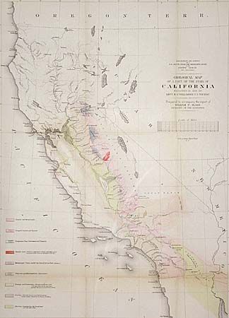
Auction 96, Lot 156
Subject: California
Williamson, R. S. (Lt.)
Geological Map of a Part of the State of California, 1855
Size: 16.1 x 22.2 inches (40.9 x 56.4 cm)
Estimate: $120 - $150
Sold for: $100
Closed on 9/12/2001
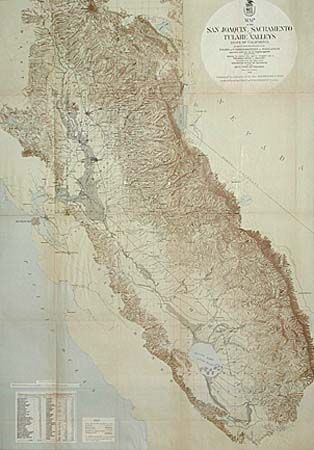
Auction 96, Lot 157
Subject: California
U.S. Army
Map of the San Joaquin, Sacramento and Tulare Valleys State of California…, 1873
Size: 24 x 34 inches (61 x 86.4 cm)
Estimate: $250 - $300
Sold for: $300
Closed on 9/12/2001
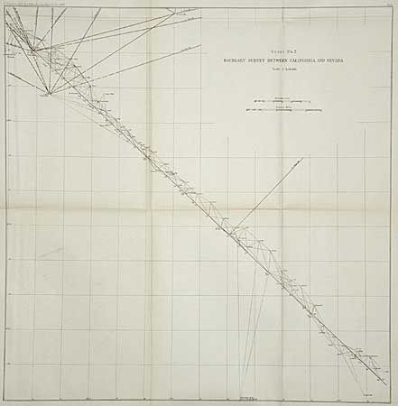
Auction 96, Lot 158
Subject: California & Nevada
U.S. Coast & Geodetic Survey
Boundary Survey between California and Nevada (Sheet 1 & 2), 1896
Size: See Description
Estimate: $50 - $60
Sold for: $25
Closed on 9/12/2001
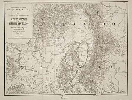
Auction 96, Lot 160
Subject: Colorado & New Mexico
Ruffner, Lt. E.H.
Map Showing the lines of Communication between Southern Colorado and Northern New Mexico, 1876
Size: 18.5 x 14 inches (47 x 35.6 cm)
Estimate: $200 - $250
Sold for: $150
Closed on 9/12/2001
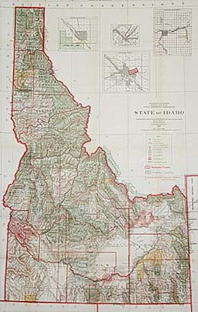
Auction 96, Lot 164
Subject: Idaho
General Land Office
State of Idaho. Compiled from the official Records of the General Land Office and other sources…, 1909
Size: 28 x 43.7 inches (71.1 x 111 cm)
Estimate: $150 - $170
Sold for: $80
Closed on 9/12/2001
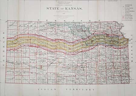
Auction 96, Lot 166
Subject: Kansas
General Land Office
State of Kansas, 1879
Size: 30.2 x 22 inches (76.7 x 55.9 cm)
Estimate: $100 - $150
Sold for: $160
Closed on 9/12/2001
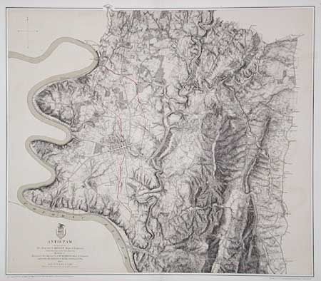
Auction 96, Lot 171
Subject: Maryland
U.S. War Department
Antietam, 1867
Size: 25.5 x 22.2 inches (64.8 x 56.4 cm)
Estimate: $250 - $300
Sold for: $425
Closed on 9/12/2001
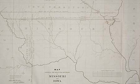
Auction 96, Lot 173
Subject: Missouri and Iowa
U.S. Government
Map Showing the Disputed Boundary of Missouri and Iowa, 1839
Size: 29.2 x 17.8 inches (74.2 x 45.2 cm)
Estimate: $100 - $150
Sold for: $50
Closed on 9/12/2001
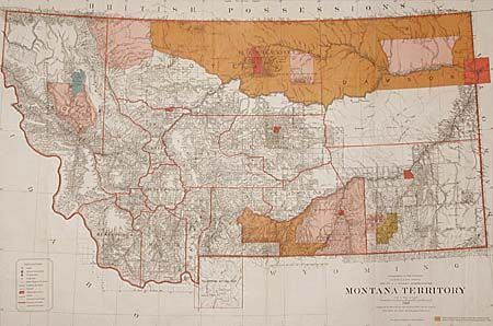
Auction 96, Lot 174
Subject: Montana
General Land Office
Montana Territory, 1887
Size: 39 x 26.2 inches (99.1 x 66.5 cm)
Estimate: $200 - $250
Sold for: $275
Closed on 9/12/2001
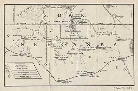
Auction 96, Lot 175
Subject: Nebraska and South Dakota
U.S. Government
Map Showing Positions of Nebraska State Troops in Indian Campaigns of the Winter of 1890-91, 1895
Size: 12 x 7.5 inches (30.5 x 19.1 cm)
Estimate: $100 - $150
Sold for: $50
Closed on 9/12/2001
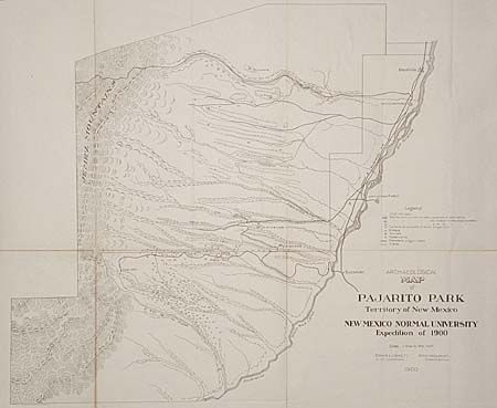
Auction 96, Lot 178
Subject: New Mexico
Anon.
Archeological Map of Pajarito Park, Territory of New Mexico. New Mexico Normal University Expedition of 1900, 1900
Size: 25 x 21.2 inches (63.5 x 53.8 cm)
Estimate: $100 - $120
Sold for: $85
Closed on 9/12/2001
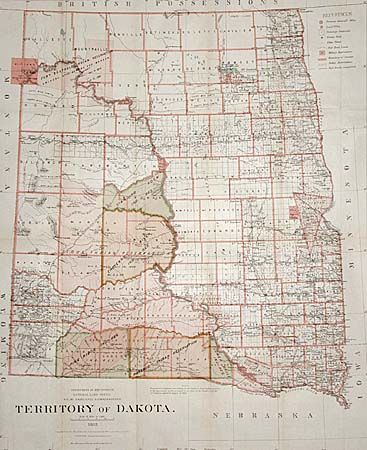
Auction 96, Lot 184
Subject: North and South Dakota
General Land Office
Territory of Dakota, 1882
Size: 23.6 x 29 inches (59.9 x 73.7 cm)
Estimate: $200 - $300
Sold for: $120
Closed on 9/12/2001
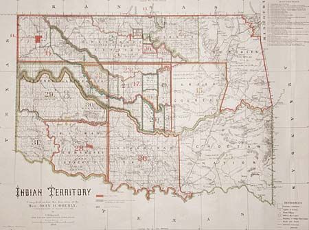
Auction 96, Lot 185
Subject: Oklahoma
U.S. Bureau of Indian Affairs
Indian Territory Compiled under the direction of Hon: John H. Oberly, Commissioner of Indian Affairs, 1889
Size: 31.6 x 23.5 inches (80.3 x 59.7 cm)
Estimate: $250 - $300
Sold for: $550
Closed on 9/12/2001
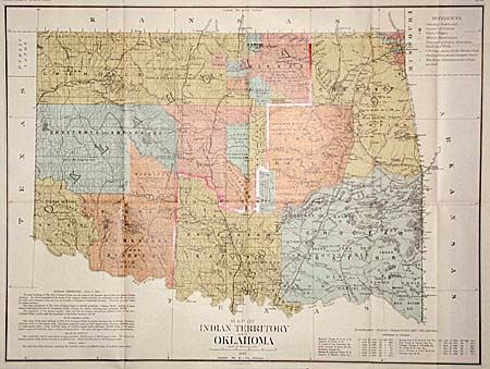
Auction 96, Lot 186
Subject: Oklahoma
U.S. Government
Map of Indian Territory and Oklahoma, 1890
Size: 29.5 x 22 inches (74.9 x 55.9 cm)
Estimate: $200 - $300
Sold for: $230
Closed on 9/12/2001
Auction 96, Lot 187
Subject: Oregon and Washington
Dixon, Joseph (Lt)
Map Showing the Routes travelled by the Command of Majr E. Steen, U. S. Drags., against the Snake Indians in 1860, 1860
Size: 34 x 24.5 inches (86.4 x 62.2 cm)
Estimate: $150 - $250
Sold for: $250
Closed on 9/12/2001
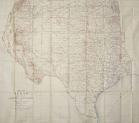
Auction 96, Lot 194
Subject: Texas and New Mexico
U.S. Geological Survey (USGS)
Map of Texas and parts of Adjoining Territories, 1899
Size: 35 x 31 inches (88.9 x 78.7 cm)
Estimate: $250 - $300
Sold for: $180
Closed on 9/12/2001
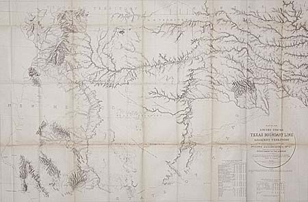
Auction 96, Lot 195
Subject: Texas
U.S. Geological Survey (USGS)
Map of the United States and Texas Boundary Line and Adjacent Territory determined & surveyed in 1857-8-9-60, by J.H. Clark U.S. Commissioner, 1902
Size: 39.5 x 26.2 inches (100.3 x 66.5 cm)
Estimate: $200 - $300
Sold for: $120
Closed on 9/12/2001
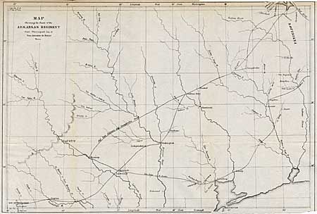
Auction 96, Lot 196
Subject: Texas
U.S. Government
Map Showing the Route of the Arkansas Regiment from Shreveport, La. to San Antonio de Bexar, Texas, 1850
Size: 17.2 x 11.6 inches (43.7 x 29.5 cm)
Estimate: $150 - $200
Sold for: $140
Closed on 9/12/2001
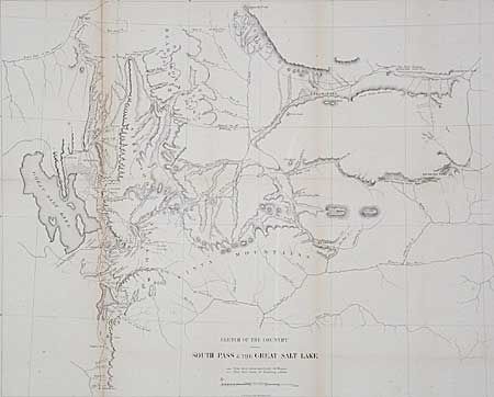
Auction 96, Lot 198
Subject: Utah and Wyoming
U.S. Government
Sketch of the Country between South Pass & the Great Salt Lake, 1857
Size: 21.5 x 17.4 inches (54.6 x 44.2 cm)
Estimate: $100 - $120
Sold for: $100
Closed on 9/12/2001
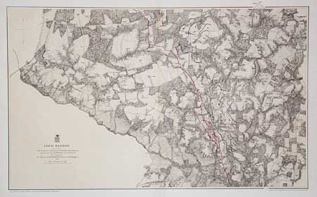
Auction 96, Lot 201
Subject: Virginia
U.S. War Department
Cold Harbor, 1867
Size: 32.5 x 19.8 inches (82.6 x 50.3 cm)
Estimate: $200 - $250
Sold for: $350
Closed on 9/12/2001
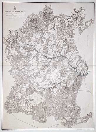
Auction 96, Lot 202
Subject: Virginia
U.S. War Dept.
Appomattox Court House, 1867
Size: 22.2 x 30.5 inches (56.4 x 77.5 cm)
Estimate: $250 - $300
Sold for: $150
Closed on 9/12/2001
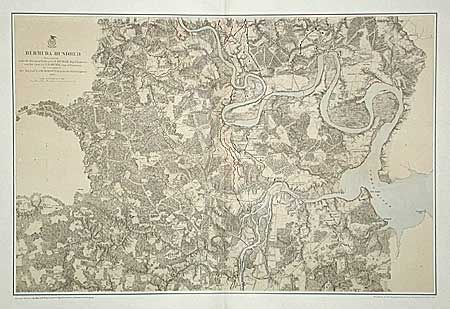
Auction 96, Lot 203
Subject: Virginia
U.S. War Dept.
Bermuda Hundred, 1867
Size: 28.8 x 19.1 inches (73.2 x 48.5 cm)
Estimate: $200 - $250
Sold for: $190
Closed on 9/12/2001
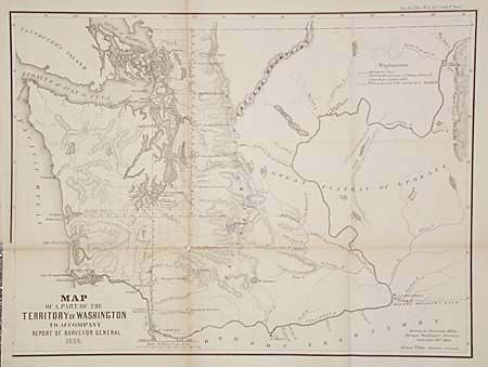
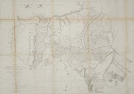
Auction 96, Lot 204
Subject: Washington
U.S. State Surveys
Map of a part of the Territory of Washington to accompany Report of the Surveyor General, 1855
Size: 19.2 x 14.4 inches (48.8 x 36.6 cm)
Estimate: $100 - $150
Sold for: $275
Closed on 9/12/2001
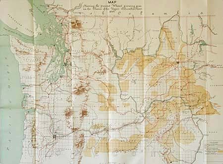
Auction 96, Lot 205
Subject: Washington
U.S. Government
Map Showing the present Wheat growing area in the Basin of the Upper Columbia River, 1892
Size: 29 x 21.5 inches (73.7 x 54.6 cm)
Estimate: $60 - $70
Sold for: $30
Closed on 9/12/2001
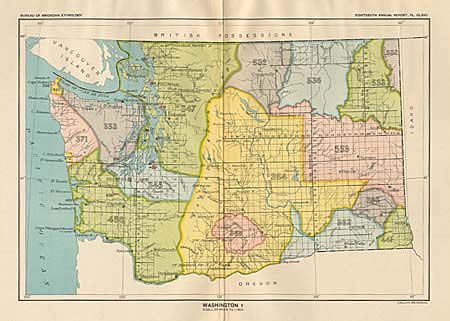
Auction 96, Lot 206
Subject: Washington
U.S. Bureau of Ethnology
[Lot of 4 maps], 1899
Size: See Description
Estimate: $30 - $40
Sold for: $0
Closed on 9/12/2001
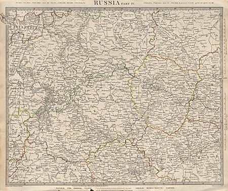
Auction 96, Lot 339
Subject: Russia
SDUK Society for the Diffusion of Useful Knowledge
Russia Part IV, 1834
Size: 15.2 x 12.3 inches (38.6 x 31.2 cm)
Estimate: $30 - $35
Sold for: $20
Closed on 9/12/2001
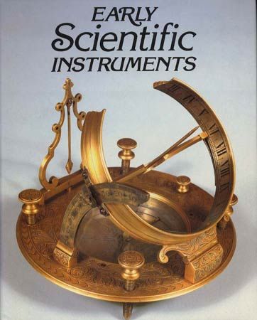
Auction 96, Lot 575
Subject: Scientific Instruments
Hawkes, Nigel
Early Scientific Instruments, 1981
Size: 9.3 x 11.4 inches (23.6 x 29 cm)
Estimate: $90 - $110
Sold for: $130
Closed on 9/12/2001
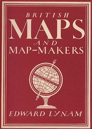
Auction 96, Lot 577
Subject: Cartographic Reference
Lynam, Edward
British Maps and Map-Makers, 1944
Size: 6.5 x 9 inches (16.5 x 22.9 cm)
Estimate: $20 - $25
Sold for: $70
Closed on 9/12/2001
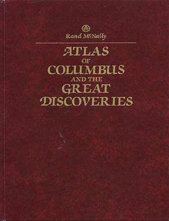
Auction 96, Lot 602
Subject: Cartographic Reference
Nebenzahl, Kenneth
Atlas of Columbus and the Great Discoveries, 1990
Size: 11.3 x 14.8 inches (28.7 x 37.6 cm)
Estimate: $50 - $60
Sold for: $0
Closed on 9/12/2001
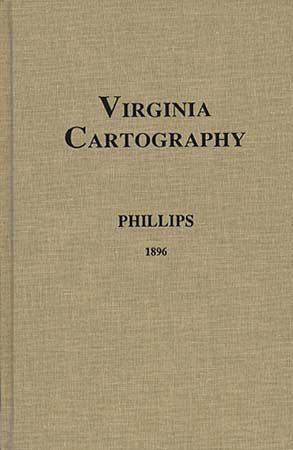
Auction 96, Lot 609
Subject: Cartographic Reference
Phillips, P. Lee
Virginia Cartography - A Bibliographical Description, 1995
Size: 6.2 x 9.7 inches (15.7 x 24.6 cm)
Estimate: $20 - $30
Sold for: $10
Closed on 9/12/2001

Auction 96, Lot 614
Subject: Cartographic Reference
French, J. H.
Tooley's Dictionary of Mapmakers, Revised Edition A-D, 1999
Size: 7.3 x 10.1 inches (18.5 x 25.7 cm)
Estimate: $80 - $100
Sold for: $95
Closed on 9/12/2001
48 lots