Filtered by Category:Pacific Ocean, New Zealand, Australia(Show All Categories)
Showing results for:Auction 98
Catalog Archive
7 lots
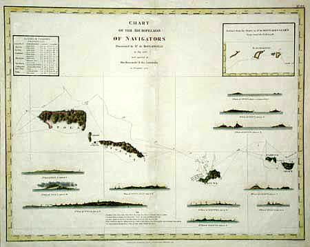
Auction 98, Lot 417
Subject: Pacific Islands
La Perouse, Comte Jean F. Galoup, de
Chart of the Archipelago of Navigators Discovered by Mr. De Bougainville in May 1768 and explored by the Boussole & the Astrolabe in December 1787, 1798
Size: 19.2 x 15 inches (48.8 x 38.1 cm)
Estimate: $250 - $300
Sold for: $130
Closed on 3/6/2002
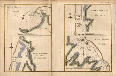
Auction 98, Lot 418
Subject: French Polynesia
Cook/Hogg
Baye de Matavai a Otahiti; Havere d'Ohamaneno a Ulieta; Havre d'Owharre dans l'Isle d'Huaheine; Havre d'Oopoa a Ulietea, 1780
Size: 13.2 x 8.5 inches (33.5 x 21.6 cm)
Estimate: $60 - $80
Sold for: $75
Closed on 3/6/2002
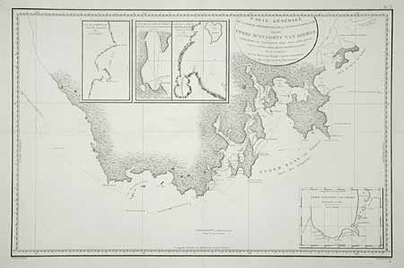
Auction 98, Lot 419
Subject: Tasmania
Beautemps-Beaupre, Charles Francois
[Lot of 2] Carte Generale de la Partie Meridionale de la Nouvelle Hollande, appelee Terre d'Anthony van Diemen… [and] Carte Particuliere du Canal Dentrecasteaux, entre la Terre Meridionale d'Anthony Van Diemen et l'Ile Bruny, Levee et Dressee, 1807
Size: 29.7 x 19.2 inches (75.4 x 48.8 cm)
Estimate: $650 - $750
Sold for: $550
Closed on 3/6/2002
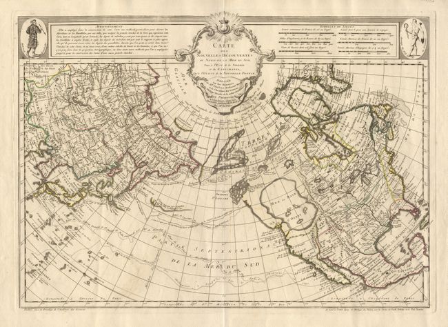
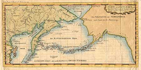
Auction 98, Lot 420
Subject: Western North America and North Pacific
Delisle/Buache
Carte des Nouvelles Decouvertes au Nord de la Mer du Sud, Tant a l'Est de la Siberie et du Kamchatka, qu'a l'Ouest de la Nouvelle France, 1750
Size: 25 x 17.8 inches (63.5 x 45.2 cm)
Estimate: $5,000 - $6,000
Unsold
Closed on 3/6/2002
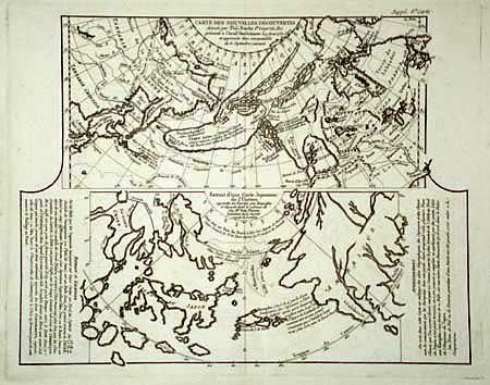
Auction 98, Lot 421
Subject: North Pacific Ocean
Robert de Vaugondy/Diderot
Carte des Nouvelles Decouvertes [on sheet with] Extrait d'une Carte Japonoise de l'Univers, 1752
Size: 14.8 x 11.5 inches (37.6 x 29.2 cm)
Estimate: $220 - $300
Sold for: $160
Closed on 3/6/2002
Auction 98, Lot 423
Subject: North Pacific - Arctic
Anon.
Carte der Entdekungen Zwischen Sibirien und America bis auf das Jahr 1780, 1781
Size: 16.2 x 7.7 inches (41.1 x 19.6 cm)
Estimate: $140 - $180
Sold for: $140
Closed on 3/6/2002
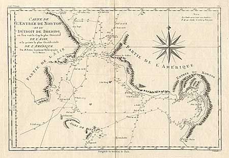
Auction 98, Lot 424
Subject: North Pacific - Arctic
Bonne, Rigobert
Carte de l'Entree de Norton, et du Detroit de Bhering ou l'on voit le Cap le plus Oriental de l'Asie, et la Pointe la plus Occidentale de l'Amerique, 1788
Size: 13.5 x 9 inches (34.3 x 22.9 cm)
Estimate: $120 - $150
Sold for: $90
Closed on 3/6/2002
7 lots