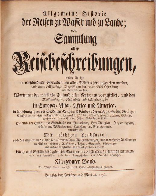
"Allgemeine Historie der Reisen zu Wasser und zu Lande...", Prevost, Anton Francois
Subject: Exploration & Surveys
Period: 1756 (published)
Publication:
Color: Black & White
Size:
8.1 x 9.8 inches
20.6 x 24.9 cm
This is Volume 14 of the German edition of Prevost d'Exile's influential history of voyages, Histoire Generale des Voyages..., which featured maps and plans by Nicholas Bellin. The German edition was published by Arkstee and Merkus in Leipzig in 21 volumes between 1747-74. This volume focuses on Canada and the United States, with 18 re-engraved maps based on Bellin. Only the first map is signed by the engravers Leonard Schenk and J. Soon; none of the other maps include an engraver's imprint. The maps included are:
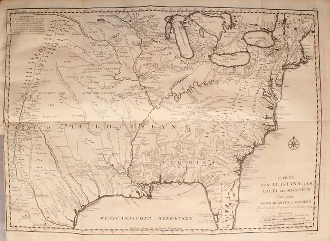
A. Karte von Luisiana, dem Laufe des Mississipi und den Benachbarten Laendern, dated 1744 (21.8 x 15.4"). This finely engraved map covers the region from the Great Lakes to the Gulf of Mexico over to the Rocky Mountains and Santa Fe. The information in the west includes the road from Mexico City to Santa Fe and the routes of St. Denis and De Soto though Texas. The map shows strategic forts and areas claimed by the French just prior to the French and Indian War. Incredible detail of settlements, Indian tribes, rivers, and trails. The map is adorned by a nice compass rose. References: Brown (Ohio) pp. 69-70; cf. McCorkle #744-1; cf. Tooley (MCC-96) #703. Condition: Minor offsetting and very light toning at far left. There is a short binding tear that enters the map border at left and an adjacent mis-fold along the edge. (B+)
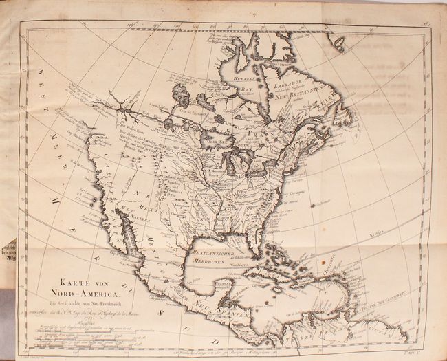
B. Karte von Nord-America, zur Geschichte von Neu-Frankreich, dated 1755 (13.7 x 11"). This map of North America illustrates the travels of Pierre Francois Xavier de Charlevoix, a Jesuit who explored the French colonies in North America in the early part of the eighteenth century. The most distinctive feature of the map is the River of the West shown as a definitive waterway flowing west from Lake Superior to the Pacific Ocean near the Berg von glanzen den Steinen (mountain of brilliant stones). The actual northwest coastline is indistinct with notations of the discoveries of Martin d'Aguilar. The Missouri, Rio Grande (Nord-Fluss), and Colorado Rivers all originate near each other beneath a notation to the effect that reports of the kingdoms of Quivira and Taguiao are uncertain. The Mississippi River system and the Great Lakes reflect Charlevoix's travels in the region and reports he compiled from fur traders. Condition: Light offsetting at far left and top right from an opposing page of text, a few small spots of foxing, and a short binding tear that just enters the neatline at left. (B+)
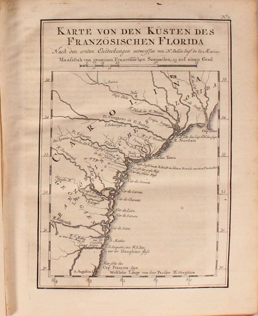
C. Karte von den Kusten des Franzosischen Florida (5.6 x 7.9"). This map covers the coast from Cape Fear to St. Augustine and shows the locations of Spanish, French and English settlements in the region. There are several errors of location including the misplacement of Jamestown and Charlestown together. A notation (in German) shows the location of Charlesfort that was built by the French explorer, Jean Ribault on Parris Island in South Carolina. It also provides both Ribault's rivers names as well as the contemporary names.Condition: Light toning. (B+)
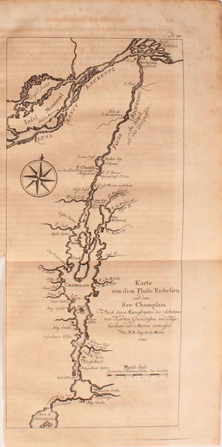
D. Karte von dem Flusse Richelieu und dem See Champlain, dated 1744 (5.3 x 11.8"). Montreal and Lake Champlain, including the rivers Richelieu and St. Lawrence, are the focus of this detailed little chart. Montreal is here called Saint Maria. Lake Champlain was the major transportation route between the Saint Lawrence and Hudson valley during the colonial period. The French forts Chambly, l'Assomption, Richelieu and St. Frederic (Crown Point) attest to the importance of the region. Condition: Light offsetting with moderate toning. (B)
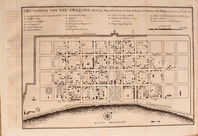
E. Grundriss von Neu-Orleans, dated 1744 (11 x 7.6"). Condition: Light offsetting and toning. (B+)
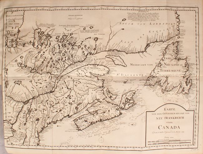
F. Karte von dem Ostlichen-Stucke von Neu Frankreich oder Canada, dated 1744 (21.6 x 15.4"). Condition: Minor toning. (A)
G. Karte von Accadia Nach den Manuscripten des Vorrathes von Karten und Grundrisen bey der Marine Entworfen, dated 1744 (12.5 x 7.9"). Condition: Light toning and offsetting. (B+)
H. Karte von der Insel Montreal und den Gegenden Umher, dated 1744 (12.1 x 9.5"). Condition: Light offsetting with one spot of foxing. (B+)
I. Karte von dem Eylande Terre-Neuve, dated 1744 (14 x 11.2"). Condition: Minor toning. (A)
J. Karte von den Bayen, Rheeen und Hafen von Plaisance auf der Insel Terre Neuve, dated 1744 (11.2 x 7.6") Condition: Faint offsetting. (A)
K. Karte von der Hudsons Bay, dated 1744 (11.2 x 8"). Condition: Light offsetting. (B+)
L. Karte von dem Ende der Hudsons-Bay Welche die Englander James Bay Nennen, dated 1744 (5.5 x 7.5"). Condition: Light toning and offsetting from an opposing page of text. (B+)
M. Grundriss von Port Royal in Accadia von den Englaendern Annapolis Royale Genannt, dated 1744 (11 x 7.6"). Condition: Light offsetting. (B+)
N. Grundriss des Hafens la Haive an der Kuste von Accadien, dated 1744 (11 x 7.8"). Condition: Light offsetting and toning. (B+)
O. Grundriss von der Bay Chedabuctu Heutiges Tages Havre de Milfort, dated 1744 (11.1 x 7.8"). Condition: Light offsetting and toning. (B+)
P. Karte von l'Isle Royale, dated 1744 (10.5 x 8.9"). Condition: Light offsetting and toning. (B+)
Q. Grundriss des Hafens und der Stadt Louisbourg oder Ludwigsburg auf der Koenigs-Insel / Plan du Port et Ville de Louisbourg dans l'Isle Royale (10.9 x 7.6"). Condition Light offsetting with moderate toning. (B)
R. Grundriss des Hafens Dauphin und Seiner Rheede, dated 1744 (11.1 x 7.7"). Condition: Light offsetting and toning. (B+)
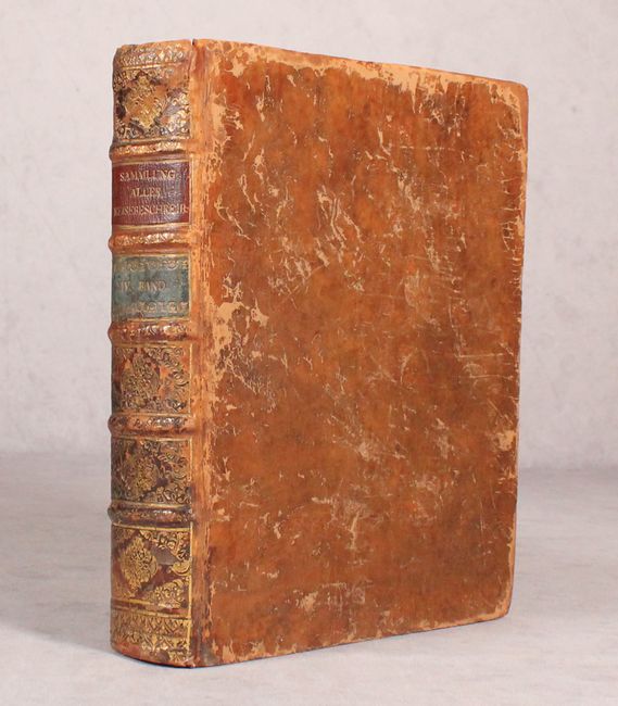
Octavo, iii-v; list of maps, 648 pp., [38 pp.]. Hardbound in original full leather with raised bands, red and blue leather title labels, and gilt tooling on spine.
References: Sabin #65406.
Condition: B+
The majority of the maps are in B+ condition, with 3 maps in A condition and 2 maps in B condition. See description above for condition details on each map. The text is very good with light toning. The hinges are starting, the covers are moderately worn with abrasions and bumped corners, and the spine has some abrasions with a small chip at top left.