"Delta of the Mississippi. Surveyed at the Suggestion of the Special Board of Engineers, Appointed to Devise a Plan for Improving the Entrance of the Mississippi River...", Talcott, Capt. Andrew
Subject: Mississippi River, Louisiana
Period: 1839 (dated)
Publication: No. 463, 26th Congress, 1st Session
Color: Black & White
Size:
29.8 x 41.6 inches
75.7 x 105.7 cm
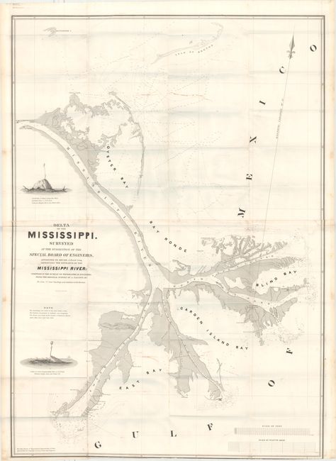
Andrew Talcott, U.S. Topographical Engineer, conducted the first detailed survey of the Mississippi River delta from February to July, 1838. The results of the survey were compiled and printed the following year. At the time, New Orleans was the fifth largest city in the United States and the dominant port on the Gulf of Mexico; the economy of the city was entirely tied to river commerce. Steamboat traffic had grown dramatically from the city's inception in 1812 to the 1830s, so getting material to New Orleans from the entire upper Mississippi basin took a fraction of the time it had previously. The problem of continuous navigation by seagoing vessels through the passes of the Mississippi into the Gulf had not been adequately addressed. The impetus for the Talcott survey in 1838 was to determine a way to increase water depths over the river mouth bars to allow year-round, unfettered river/Gulf boat traffic; the first step was an accurate survey.
Several interesting landmarks are noted on the chart. At Northeast Pass, the "North East Light" is shown near a "Salt Spring." This lighthouse is more commonly known as the Frank’s Island light and was put into service in March 1823 when Northeast Pass was preferred over the other river entrances by mariners. Initially contemplated by architect Benjamin Latrobe in 1817 as a classical stone structure, the original lighthouse failed prior to completion due to the heavy mass built on deltaic mud. The second, simpler lighthouse attempt proved highly successful and was used until completion of the light at the nearby Pass a Loutre in 1856. Over time, the structure sank vertically into the mud some 20 feet before it was destroyed by a hurricane in 2002. Also shown nearby is the location of the historic Spanish and French Balize on Balize Bayou, noted as "Old Spanish Magazine." The chart covers the area from the Gulf to Fort St. Phillip (1810) and Ft. Jackson (1832) across the river on the north. "South Light" appears on the sand spit at the mouth of South Pass. Completed in 1832, the light existed only until 1839, when the structure was torn from its foundation by logs swept downriver. Printed on two sheets and joined, as issued.
References: Claussen & Friis #358.
Condition: B+
Issued folding with two areas of marking or foxing and a few fold intersection splits. A portion of the joint has come loose, but the two sheets are still solidly attached. Trimmed to neatline at bottom, as issued.