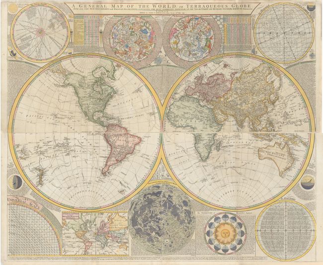
Dunn's Decorative Wall Map of the World & Heavens Showing the New Discoveries of Captain Cook
"[On 4 Sheets] A General Map of the World, or Terraqueous Globe; with All the New Discoveries and Marginal Delineations...", Dunn, Samuel
Subject: World
Period: 1794 (dated)
Publication:
Color: Hand Color
Size:
48.5 x 20.5 inches
123.2 x 52.1 cm
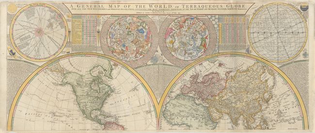
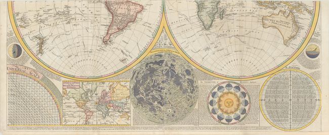
This fabulous, large map is one of the most attractive wall maps from the end of the 18th century. The huge double-hemisphere map of the world is surrounded by celestial hemispheres, a chart of the solar system, an inset world map on Mercator's projection, a map of the moon's surface after Father Riccioli, and a fascinating explanation of the Vicissitude of Seasons (with a great graphic of the sun). The large world map shows the tracks and discoveries of major voyages, including those of Captains George Anson, Louis Antoine de Bougainville, Lazier Bouvet, Aleksei Chirikov, and James Cook. The map was first issued in 1772 by Robert Sayer with the title Scientia Terrarum et Coelorum: or, the Heavens and Earth Astronomically and Geographically Delineated and Display'd... and was updated and reissued several times over a 30-year period. There were further issues by Sayer with the same title in 1781 and 1784, and the title was then updated to A General Map of the World, or Terraqueous Globe for the 1787 issue.
This example, issued by Laurie & Whittle in 1794, shows great improvements to the cartography primarily due to Cook's second and third voyages. Alaska and the Pacific Northwest have now begun to take shape with numerous new place names along the coast. The previously noted entrances of Admiral Fonte, Juan de Fuca, and Martin d'Aguilar in the Pacific Northwest are now gone, however this edition includes not just one but two proposed locations for the River of the West. The northern location connects to R. St. Charles and Lake Winnipeg, while the southern location connects to Pikes Lake and Mantons River. There are also updates to the cartography in Canada and the Arctic based on Hearne's explorations in the region. A number of new islands appear in the Pacific, such as Hawaii and New Caledonia. In South America, a small remnant of the mythical L. Parima still appears in Guiana. Australia is now named both New Holland and Terra Australis, with new place names noted along the eastern coast, including Port Jackson, the first European settlement on the Australian mainland and now part of Sydney.
Printed on four sheets, with the upper and lower pairs of sheets joined, as issued. If all four sheets were joined the map would measure 48 x 41".
References: cf. Perry & Prescott #1799.03.
Condition: B+
A crisp impression on bright sheets of paper that are watermarked "RG" with minor soiling. There are professional repairs to several fold separations, a 5.5" tear through the western hemisphere on the northern sheet, and several small chips and tears along the edges of the sheets. The first image is a composite image - the map is in two sections as described above.