"[Lot of 4] Map of Kansas, Nebraska and Colorado. Showing Also the Southern Portion of Dacotah [and] Johnson's Nebraska Dakota, Colorado Idaho & Kansas [and] Colton's Dakota and Wyoming [and] Colton's Wyoming Colorado and Utah",
Subject: Western United States
Period: 1861-76 (circa)
Publication:
Color: Hand Color
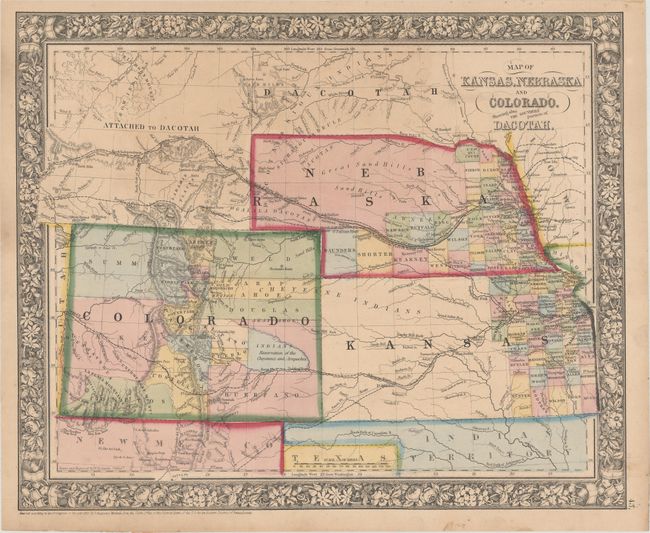
A. Map of Kansas, Nebraska and Colorado. Showing Also the Southern Portion of Dacotah, by Samuel Augustus Mitchell Jr., dated 1861 (14.1 x 11.6"). This map of the central Great Plains region depicts counties, cities, towns, transportation routes, Reservations, and topographical features. In Kansas, county development stops at Ft. Rliey, and in Nebraska the northern portion is unorganized and labelled "Great Sand Hills." In Colorado the Gold Region is noted adjacent to Denver City. This early edition has not yet labeled the newly formed Wyoming Territory, still referring to the area as "Attached to Dacotah." Condition: Minor soiling. (B+)
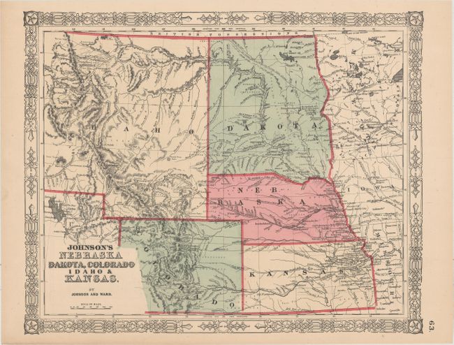
B. Johnson's Nebraska Dakota, Colorado Idaho & Kansas, by Johnson and Ward, circa 1864 (15.7 x 12.8"). Handsome map that depicts the Dakota Territory and a portion of the huge Idaho Territory as it was prior to the creation of Montana and Wyoming. There is early detail of topography and watershed. Numerous exploration and wagon routes in addition to the proposed routes for the Pacific railroads are identified. Indian tribes and army forts are noted. Surrounded by a decorative scroll-style border. Condition: Clean and bright. (A)
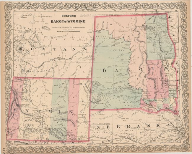
C. Colton's Dakota and Wyoming, by G.W. and C.B. Colton & Co., circa 1872 (16.6 x 13.8"). This relatively uncommon and early edition of this map was issued just after Wyoming established its first five counties in 1869, namely Uintah, Sweet Water, Carbon, Albany and Laramie. This is the first atlas map to name Wyoming in the title and to show its correct territorial configuration. It shows only a few settlements outside of the many forts and army posts. The completed Union Pacific Railroad stretches across Nebraska and the southern portion of Wyoming. Fremont's Peak is noted as being "the Loftiest known Summit in this chain." Dakota Territory has only a few counties organized along the eastern border with the balance of the territory in Indian hands but no reservations are named. Again, the short-lived county of Buffalo is shown occupying a huge swath of land laying east of the Missouri River. A string of forts are shown along the Missouri River. Numerous trails and exploration routes are noted including part of the [Pony] Express Route, Fremont and Stansbury's routes, Northern Pacific and Union Pacific Railroads and the Great Route to California and Oregon (Oregon Trail). Condition: Light toning along the sheet edges with one edge tear confined to the decorative border that is closed on verso with archival tape. (B+)
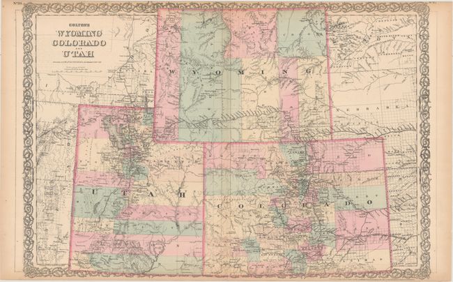
D. Colton's Wyoming Colorado and Utah, by G.W. and C.B. Colton & Co., dated 1876 (25.4 x 17.3"). This handsome and detailed double-page map shows Wyoming now divided into seven counties with the addition of Pease and Crook in the northeast. Yellowstone National Park is now shown in the northwestern corner of the territory. Prominently shows the Union Pacific Railroad, Indian reservations, and the extent of public surveying. Condition: Light toning along sheet edges with two small edge tears at bottom that just enter the border that have been closed on verso with archival tape. (B+)
References:
Condition:
See description above.