Subject: Southeast Asia & China
Period: 1720 (circa)
Publication:
Color: Hand Color
Size:
20.6 x 24.3 inches
52.3 x 61.7 cm
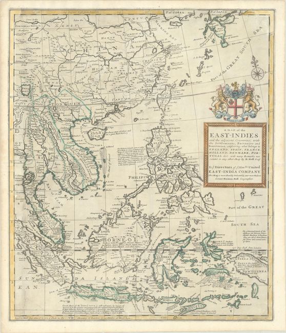
This is the eastern half of Moll's two-sheet map of Southern and Southeast Asia. This sheet focuses on China and Southeast Asia and is filled with notes on the natural resources suitable for European trade that can be found on various islands. The map is dedicated to the directors of the English East India Company, whose coat of arms sits atop the title cartouche. This map was published at the height of European trade in the region, and also attempts to identify which islands an regions "belong" (as stated in the title) to each of the colonial powers: England, Spain, France, Holland, Denmark, and Portugal. As with Moll's other maps of Asia of the time period, this map includes numerous geographical inaccuracies. Although Indonesia and the Philippines are beginning to take form, the islands are still misshapen, exaggerated, and lacking much detail. The mythical Chaamay L. is shown in southern China with several rivers flowing west and south.
Herman Moll was one of Britain's most prominent cartographers of the first half of the 18th century. He emigrated from Germany and went to work as an engraver for Moses Pitt in 1678. Soon he joined one of London's most interesting social circles, which gathered at Jonathan's Coffee House, and included stock speculators, scientists, archaeologists, authors, pirates, and sea-captains. From these friends, Moll gained a great deal of privileged information that he compiled into his cartographic works. Moll's success and prosperity was due in part to his social connections and political astuteness, and to his distinctive style and quality workmanship. He produced a great number of often-innovative maps, charts, globes, atlases and geographies. His best known works are the large two-sheet maps produced for his World Described, which were also published separately.
References:
Condition: B
A dark impression on a sheet with light printer's ink residue and minor soiling. There are professional repairs to a series of long tears in the left-hand side of the sheet, and to some chips and tears along the edges of the sheet, with the left-hand border, the top right corner, and the bottom neatline expertly replaced in facsimile. Because the repairs were done so meticulously, the map presents itself very well.