Subject: Cartographic Miscellany, New England US
Period: 1928 (published)
Publication:
Color: Printed Color
Size:
8.7 x 9.3 inches
22.1 x 23.6 cm
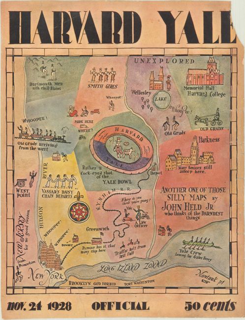
This humorous map was created by John Held Jr. for the front cover of the Harvard - Yale football program in 1928. Bounded by the Hudson River in the west and the Long Island Sound in the south, the map focuses on the major colleges in the region, such as Dartmouth, Smith, Wellesley, Vassar, Princeton, West Point, and of course, Harvard and Yale. There is little regard for geographic accuracy, as Dartmouth is illustrated at approximately the same latitude as Smith, Wellesley, and Harvard. At the center is the Yale Bowl Stadium, with Pilgrim John Harvard and Yale's Handsome Dan bulldog shown on the field. Nearby is Yale's Harkness Hall, in which one could find "many seniors still asleep." "Old grads" are shown arriving from near and far by railway, automobile and horse-drawn buggy, depicted as men in black coats, top hats, and beards.
John Held Jr. (1889-1958) was an American cartoonist who is best known for his 1920's portrayals of dancing (including the Charleston), driving, playing sports, and other popular activities of the era. During the 1920's, Held was living in Weston, Connecticut, about 30 miles west of Yale.
References:
Condition: B
Fully backed in archival tissue to repair a number of short tears along the edges of the sheet, including several that enter less than 1/2" into the image. There is a chip at top right with partial loss of the "E" in Yale.