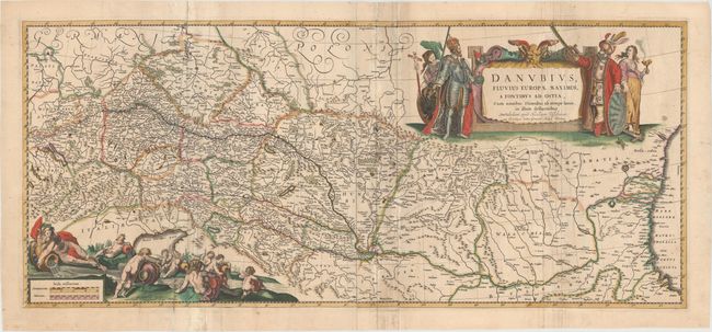
"Danubius, Fluvius Europae Maximus, a Fontibus ad Ostia, cum Omnibus Flumnibus ab Utroque Latere, in Illum Defluentibus", Visscher, Nicolas
Subject: Danube River, Southeastern Europe
Period: 1680 (circa)
Publication:
Color: Hand Color
Size:
36.9 x 16.1 inches
93.7 x 40.9 cm
This dramatic map depicts the course of the river Danube and the surrounding countries from its headwaters in the Black Forest of southern Germany to its mouth on the Black Sea. The river flows through a series of broad and fertile valleys with several of eastern Europe's most important cities on its banks. This is one of Blaeu's largest atlas maps, printed on two joined sheets. The extravagant title cartouche is flanked by the Holy Roman Emperor and Europa on one side and the Ottoman Sultan and Asia on the other, representing the long struggle between the two powers for control of the region. The scale of miles is attended by an assortment of muscular river gods and putti representing the mighty river and its tributaries. Blank verso.
References:
Condition: B
A fine impression with full original color. Issued folding with extraneous creasing and light soiling along the folds, as well as some fold separations and tiny tears along the folds that have been archivally repaired.