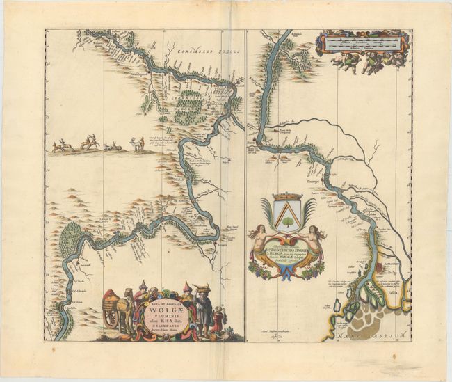
"Nova et Accurata Wolgae Fluminis, Olim Rha Dicti Delineatio Auctore Adamo Oleario", Jansson/Pitt
Subject: Volga River, Russia
Period: 1680 (circa)
Publication:
Color: Hand Color
Size:
21.5 x 18.3 inches
54.6 x 46.5 cm
This beautifully engraved map shows the Volga River in two parts based on the travels of Adam Olearius. The left side of the map charts the river between Nazhniy Novgorod and Saratov, the right side continues to Astrachan and the Caspian Sea. The map is richly embellished with a title cartouche showing tribesmen and camels with wineskins and bunches of grapes, and a distance scale cartouche festooned with putti and garlands. A dedication on the right to Benedicto Bagge de Berga is topped with his crest and flanked by two maidens above a grape garland.
Adam Olearius was a German scholar, mathematician, geographer and librarian. He was sent in 1633 by Duke Frederick III to Moscow and Persia to seek treaties favoring the newly-founded city of Friedrichstadt as the terminus for an overland silk road. The party traveled from Hamburg to Moscow via Lubeck, Riga, Dorpat, Revel, Narva, Ladoga and Novgorod. A favorable treaty was struck with Michael Romanov in 1635. Later that year Olearius returned to Moscow and then on to Persia via the Volga and the Caspian Sea. After an arduous journey he met the shah in August 1637, but negotiations were not successful. On the return trip, Olearius left his party at Revel heading directly for Lubeck. He mapped the Volga along the way, bringing this knowledge to Europe.
References: Van der Krogt (Vol. I) #1825:1.2.
Condition: A
Fine impression and color on watermarked paper with minor creasing along the centerfold. There is a pale blue shadow along the centerfold that is caused by our scanner and does not appear on the map itself.