Manuscript Map
"Plan de Grenoble",
Subject: Grenoble, France
Period: 1750 (circa)
Publication:
Color: Hand Color
Size:
16.3 x 11 inches
41.4 x 27.9 cm
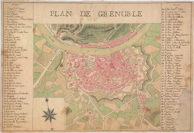
This superb manuscript map provides an excellent bird's-eye plan of the city of Grenoble, located at the foot of the French Alps in southeastern France. The plan locates 94 key sites, with a numbered key at right and left. Numerous famous locations are identified, including the church of St. Laurent, the palace at the Place Saint Andre, the Jardin de Ville, and Place Grenette. The Isere River divides the city from the ancient fortifications of the Bastille, located on the mountain-side to the north of Grenoble. The artistry of both the drawing and coloring of this map are extraordinary. The artist's signature is at bottom right, and appears to be "Girand."
The paper bears the watermark: "Fin de M [fleur-de-lis] Iohannot d'Annonay 1749." The paper was made by the Johannot family, who manufactured paper in Annonay, just 100 kilometers west of Grenoble.
References:
Condition: B
On hand-laid paper with the watermark of "Fin de M [fleur-de-lis] Iohannot d'Annonay 1749." There is moderate soiling, and several short edge tears have been archivally repaired. A large chip at bottom left has been professionally repaired with old paper, with some loss of the numbered key.