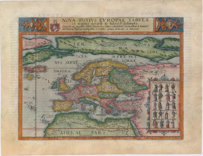
De Jode's Very Rare Map of Europe
"Nova Totius Europae Tabula ex Magnis Gerardi de Iudaeis P. Desumpta...", Jode, Gerard de
Subject: Europe
Period: 1613 (dated)
Publication: Speculum Orbis Terarrum
Color: Hand Color
Size:
17.4 x 13 inches
44.2 x 33 cm
This handsome map of Europe appeared in only one edition of de Jode's Speculum Orbis Terarrum, published in 1593 by his son, Cornelis de Jode. Cornelis revised many of the plates for the 1593 edition, published two years after Gerard's death, and added several plates, including this one. The date of 1613 (MDCXIII) in the title of the map was an error, and was meant to state 1593 (MDXCIII). The map shows good detail of the towns and rivers throughout Europe and northern Africa, however the most interesting aspect is the large landmass in the arctic, Terra Nova Zemla, depicting several Northeast Passages. A note on the landmass explains that Novaya Zemlya had been discovered by the English in 1550, and that the inhabitants were Pygmies who were "four feet long." Several mythical islands also appear in the North Atlantic, including Frislandt, S. Brandain, and Bresil. Although Cornelis claimed that the map was based on his father's work, there are few similarities between this map and Gerard's previous maps of Europe, particularly regarding the depiction of Novaya Zemlya and the greatly elongated Scandinavia. Interestingly, the cartography appears quite similar to the 1570 world map by Abraham Ortelius (see Shirley #122), one of de Jode's strong competitors.
The map is adorned with a strapwork cartouche at right depicting 20 costumed figures. The majority of the figures are male/female pairs representing the dress of various European inhabitants, although an African slave and several Turkish and Persian soldiers are also shown. The title dedicates the map to Julius Echter von Mespelbrunn, Prince-Bishop of Wurzburg from 1573 until his death in 1617. Latin text on verso.
References: Van der Heijden #37; Shirley (BL Atlases) T.JOD-1c; Van der Krogt (Vol. III) #1000:32B.
Condition: B+
Attractive old color on watermarked paper with wide margins and minor refreshing of color. There are expert and nearly invisible repairs to a few short centerfold separations and to several tears: one that extends from the centerfold to the right side of the sheet, just above the costumed figures, another that extends 4" across northern Africa, and a couple of tears that enter less than 1" into image at bottom. There are additional professional repairs to some chips and tears confined to blank margins. Despite these imperfections, this map appears in near fine condition to the naked eye, as the expert repairs are only visible when held to light.