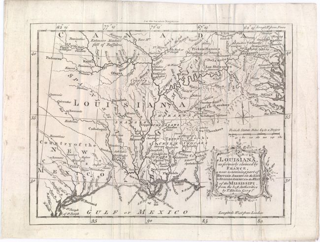
"Louisiana, as Formerly Claimed by France, Now Containing Part of British America to the East & Spanish America to the West of the Mississipi. From the Best Authorities", Kitchin, Thomas
Subject: Colonial Southern United States
Period: 1765 (dated)
Publication: London Magazine
Color: Black & White
Size:
9.1 x 7 inches
23.1 x 17.8 cm
This well-engraved map focuses on the Mississippi River valley and spans the region from Lake Erie to the Gulf Coast. Completed after the conclusion of the French and Indian Wars, the map shows the British and Spanish claims in the region formerly belonging to France, with Britain owning the land east of the Mississippi, including Spanish Florida. To compensate her ally Spain for the loss of Spanish Florida, France gave Spain the land west of the Mississippi. The map is filled with interesting details, such as the Extensive Meadows Full of Buffaloes located north of the Missouri River and the Country Full of Mines noted in present-day Tennessee. It is adorned with a typically delicate and lovely cartouche engraved by Kitchin.
References: Sellers & Van Ee #724; Jolly #LOND-245; Lemmon, Magill & Wiese, Charting Louisiana #39.
Condition: B+
Issued folding with minor soiling and several mis-folds.