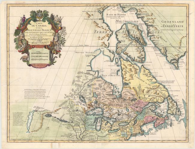
One of the Most Influential Maps of Canada, the Great Lakes and Upper Midwest
"Carte du Canada ou de la Nouvelle France et des Decouvertes qui y ont ete Faites…", Delisle/Buache
Subject: Colonial Northeastern United States & Canada, Great Lakes
Period: 1745 (circa)
Publication: Atlas Geographique et Universel
Color: Hand Color
Size:
25.5 x 19.5 inches
64.8 x 49.5 cm
First issued in 1703, this richly detailed map provides the most accurate rendering of the Great Lakes of the time, with the lakes fully enclosed and properly placed in longitude and latitude. Delisle's map of Canada and the Great Lakes is one of the most outstanding and influential maps of the eighteenth century. Detroit marks its debut on this map, only two years after its founding. Delisle's cartography is very meticulous and adds new information from Joliet, Franquelin, and the Jesuit explorers. It correctly positions the Ohio River but confuses its name with the Wabash River. West of the Mississippi Lahontan's fictitious Riviere Longue is prominently depicted. In Canada special attention is given to the rivers and lakes between Hudson Bay and the St. Lawrence, and Lac de Assenipoils (Lake Winnipeg) connects to Hudson Bay. Sanson's three islands of the Arctic are retained. The exquisite cartouche features a beaver, natives, priest and friars. This is the sixth state according to Kershaw.
References: Kershaw #313; Tooley (Amer) #40.
Condition: B+
A nice impression on watermarked paper that has been remargined at bottom with a tiny amount of neatline in facsimile. There are three tears at bottom left, one at left, and one at top left ranging in size between 1.5" to 3" that have all been professionally repaired on verso. Despite these minor flaws, the map still presents well.