Highly Decorative Map of the Americas
"L'Amerique Meridionale et Septentrionale Dressee sur les Nouvles Decouvtes et Dernieres Relations des Meilleurs Navigateurs Decetemps…", Desnos, Louis Charles
Subject: Western Hemisphere - America
Period: 1766 (dated)
Publication: Atlas General…
Color: Hand Color
Size:
27 x 18.8 inches
68.6 x 47.8 cm
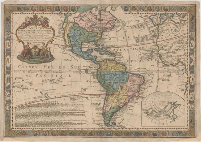
This elegant engraving is one of the more distinctive and decorative maps of the 18th century. It is based upon Guillaume Danet’s map of 1731, which in turn was based on Delisle's map of the Americas. What makes this map exceptional is the elaborate and detailed border decorations with portraits of New World explorers running along the top and bottom including Christopher Columbus, Ponce de Leon, Ferdinand Cortez and Ferdinand Magellan along with nine country seals. Illustrations of the signs of the zodiac occupy the left and right border.
Cartographically, a large Sea of the West dominates northwestern North America with the notation Communication Presumee linking it to the Hudson Bay. The Mississippi River is shown at its approximate correct location through present-day Louisiana. In South America, lakes Parime and Xarayes still appear in the interior. A large text panel provides historical notes on the explorers portrayed in the panels, while numerous other notes across the map provide a fascinating complement to the geography.
References: McGuirk #83.
Condition: B+
Attractive color on watermarked paper with a small hole near southern Africa that has been professionally infilled and two small chips along the bottom of the sheet replaced with old paper, with a very small portion of neatline in facsimile. There are a few tiny wormholes only visible when held to light and light printer's ink residue.