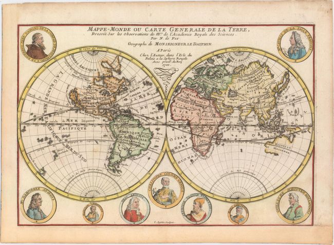
"Mappe-Monde ou Carte Generale de la Terre, Dressee sur les Observations de Mrs. de l'Academie Royale des Sciences", Fer, Nicolas de
Subject: World
Period: 1700 (dated)
Publication: L'Atlas Curieux ou le Monde
Color: Hand Color
Size:
13.6 x 9.1 inches
34.5 x 23.1 cm
Fine double hemispheric map that features California as an island. Surrounding the hemispheres are nine medallion portraits of explorers, including La Salle, Tachard, Dampier, Magellan, Drake, Columbus, Vespucci, Marco Polo, and Schouten. The map shows early mapping of North America with the Great Lakes not completely formed. The northeast coast of Asia includes a coastline labeled Roye. de Coree stretching off the map in the direction of North America. Australia and New Zealand are tentatively drawn and named Nouvelle Hollande and Nouv. Zeelande. According to Shirley, this map may have been copied directly from the similar map by Mortier (see Shirley #572), however since the dating on the Mortier map is uncertain, it is possible that Mortier copied de Fer.
References: Shirley #601; Pastoureau, FER 1.
Condition: B+
Professionally remargined at left and bottom with a few minor spots in the image.