Subject: Gulf of Mexico
Period: 1724 (circa)
Publication:
Color: Hand Color
Size:
22.8 x 20.3 inches
57.9 x 51.6 cm
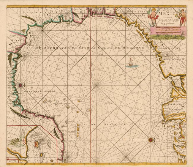
Two compass roses orient this stunning chart with north to the right. It covers the western portion of the Gulf of Mexico, stretching from the panhandle of Florida around to the Yucatan peninsula. Van Keulen's chart was mostly derived from an exceedingly rare chart by Hessel Gerritsz, c. 1631. Of note, the panhandle of Florida lacks any familiar form and the Baja de Spirito Sancto represents the mouth of the Mississippi River. An inset at lower left shows the seaport of Vera Cruz and the island Fort of San Juan d'Ulloa. The chart was engraved by the eminent geographer and mathematician Claes Janszon Vooght. It originally appeared Johannes van Keulen's fourth volume of the Zee-Fakkel in 1684. This is the fourth and final state with the imprint changed to Gerard van Keulen and the engraver's imprint removed. The plate was reworked with numerous additional toponyms, the entire Mississippi delta re-engraved, and extensive soundings added in the waters off the coast between Florida and Texas
Gerard Van Keulen was the son of Johannes van Keulen, patriarch of perhaps the most prolific of all Dutch map making families. The family firm commenced in 1680, but it was Gerard who brought it to its full glory in the 18th century. A talented engraver and mathematician, and later Hydrographer to the East India Company, Gerard became the mainspring of the business, issuing many important charts and books on all aspects of geography, navigation, etc. Until the opening of the Dutch Hydrographic Office in the 19th century, the Van Keulen firm issued what were regarded as the official Dutch sea charts.
References: Burden #592; Martin & Martin #11.
Condition: A