Subject: Mexico
Period: 1579 (dated)
Publication:
Color:
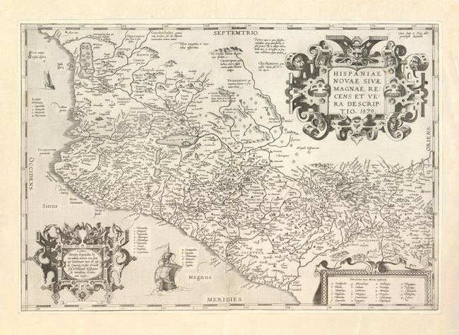
1. Hispaniae Novae sivae Magnae, Recens et Vera Descriptio, Abraham Ortelius, Theatrum Orbis Terrarum, Antwerp, 1579, 20" x 13.6" This is the first state of this important map, depicting the central and western coastal regions of Mexico. This is a cornerstone map of New Spain and the prototype for most maps of the early 17th century. It covers the Pacific coast from present-day Acapulco to about Mazatlan and inland to Mexico City, which is situated on a large lake. Several gold and silver mines are located in the central region. The map is beautifully embellished with three fine strapwork cartouches and two Spanish galleons. Fully engraved seas in stipple. This example was published in 1579 or 1580, as indicated by the Latin text and page number 5a on the verso. Map is trimmed to neatline and laid on a full sheet of period paper. Some other repairs to map, expertly accomplished. (B+)
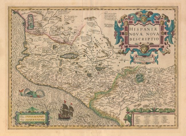
2. Hispaniae Novae Nova Descriptio, Mercator/Hondius, Amsterdam, circa 1618, 19" x 13.8" Splendid, decorative map of Mexico based on Ortelius. Mexico City is situated on a large lake with several gold and silver mines located in the central region. On the West Coast is a large inland sea filled with islands where the natives supposedly extracted salt. The map is fully decorated with three elaborate, strapwork cartouches. A Spanish Galleon and a fanciful sea monster adorn the ocean. French text with page number 369 and "Cccccccc" on verso. Very nice impression and color. On soft paper with good margins. Long printer's crease, two tears enter map from bottom, both old repairs on verso. And some extraneous creases along centerfold. (C+)
References: 1. Wagner #119, Van den Broecke #13.
Condition:
See individual descriptions.