Subject: Asia
Period: 1713 (circa)
Publication: Le Nouveau Theatre de Monde
Color: Hand Color
Size:
25.7 x 18.3 inches
65.3 x 46.5 cm
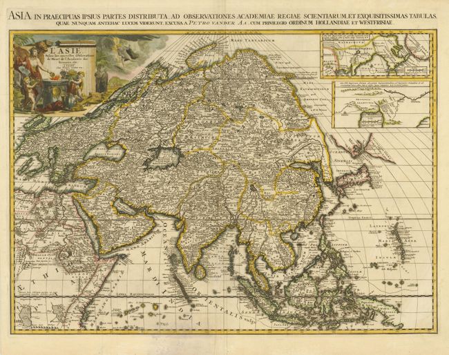
The main focus of this important and scarce map of Asia is the delineation of the northeast part of the continent from Jesuit sources. The northeast coast is severely truncated with Witsen's Icy Cape protruding into the Mare Kaymachitarum at the Arctic Circle. The partial coastlines of Jesso and Compagnies Land are depicted to the north of Japan. Inset in the North Pacific is a map of that same region based on the information from Father Martino Martini. It shows Jesso connected to the mainland with a narrow strait between it and a huge Compagnies Land. An inset below, taken from Father Ferdinand Verbiest, illustrates the road between Peking and Kirin and Nincrita. Father Verbiest's world map of 1674, which he compiled for the Chinese, subsequently led to the Jesuits obtaining a commission to make a comprehensive topographical survey for the empire. Although this was not completed until 1717, evidence that some of this new information was reaching Europe before that date is found on this map. The large title cartouche shows the female representation of Asia surrounded by a wealth of trade goods with a caravan in the background. A Latin title is in the top margin: "Asia in Praecipuas Ipsius Partes Distributa…"
References: Yeo #108.
Condition: B+
Dark impression and lovely old color. These are some faint stains in the lower part of the map, just below the Maldives.