Subject: Arabia
Period: 1572 (circa)
Publication: Civitates Orbis Terrarum, Vol I
Color: Hand Color
Size:
18.4 x 7.3 inches
46.7 x 18.5 cm
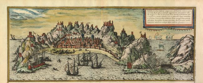
Braun & Hogenberg's Civitates Orbis Terrarum or "Cities of the World" was published between 1572 and 1617. Within the six volumes, 531 towns and cities were depicted on 363 plates, providing the reader with the pleasures of travel without the attendant discomforts. Braun wrote in the preface to the third book, "What could be more pleasant than, in one's own home far from all danger, to gaze in these books at the universal form of the earth . . . adorned with the splendor of cities and fortresses and, by looking at pictures and reading the texts accompanying them, to acquire knowledge which could scarcely be had but by long and difficult journeys?" Braun and Hogenberg incorporated an astonishing wealth of information into each scene beyond the city layout and important buildings. The plates provide an impression of the economy and prominent occupations, and illustrate local costumes, manners and customs.
A fabulous coastal view of the city of Aden surrounded by several hills, each topped by a castle, which served as lights to guide mariners into port. Aden was one of the most important Arabian trade cities and the view imparts its prominence with scenes of ship building and heavily laden ships in the harbor. This is the top half of a folio sheet, which also included views of other Arabian and Eastern Africa ports. Information for the view was supplied by the Hanse merchant Constantin van Lyskirchen from a Portuguese manuscript. Latin text on verso describes the port of Aden.
References: Fussel pp. 126-28; Norwich #332; Tooley (MCC) #30; Koeman (II) B&H 1-53.
Condition: A