Subject: Wales
Period: 1680 (published)
Publication: Britanna
Color: Hand Color
Size:
17.8 x 13.8 inches
45.2 x 35.1 cm
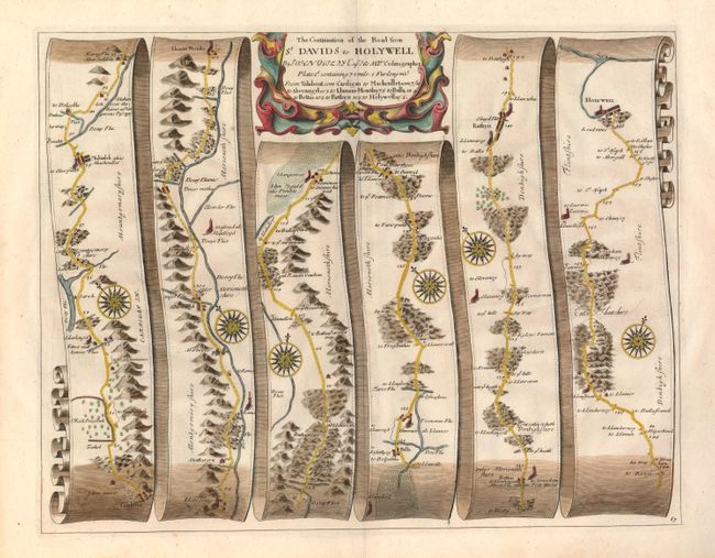
John Ogilby's 'Britannia' was published between 1675 and 1698. It is a landmark in the mapping of England and Wales. Its unique format constituted the first national road-atlas of any country in Western Europe. It was composed of maps of seventy-three major roads and cross-roads, presented in a continuous strip-form, on a uniform scale of one inch to a mile. Each beautiful map includes wonderful detail of the countryside with each strip containing a large compass rose to indicate changes in direction.
This handsome road map is in the pictorial style pioneered by Ogilby with the road laid out in several ribbon-like panels. The road travels though Wales to include the counties of Montgomeryshire, Merionethshire, Denbighshire and Flintshire just south of Holywell. The road stretches from milepost 79 to 156 as the route goes through the villages of Mahunleh (alias Machenllet), Llanum Mowthy, Aberangel, Balla, Ruthyn and more. Lead mines are located close to Holywell and Silver mines are shown next to Talabont in Montgomeryshire. The road continues to the sea just above Holywell. Holywell takes its name from the town's major feature, the St. Winefride's Holy Well; one of the Seven Wonders of Wales. Each of the six panels has a decorative compass rose to orient the traveler. The title cartouche is in a strapwork and garland style.
References:
Condition: A
Very nice impression and color on a full sheet with wide, original margins. A few light spots in blank margins, otherwise a fine example.