Subject: Japan
Period: 1756 (published)
Publication:
Color: Hand Color
Size:
23.7 x 19.4 inches
60.2 x 49.3 cm
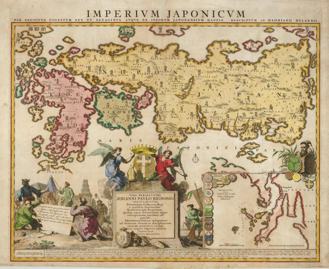
A large inset of the vicinity of Nagasaki and graphic scenes distinguish this interesting map of Japan. While the cumulative European knowledge of the vicinity of Nagasaki was used for the inset map, the main map was drawn largely from a Japanese woodblock map from the library of Benjamin Dutry, a prominent Dutch East India Company official. This Japanese map presented a distorted view of Japan, particularly Honshu, because the geographical shape was made to fit the format - in this case that of a folding travel map. Thus the Reland map represents a step backwards in the depiction of Honshu in European cartography. However, its description of Kyushu is not surpassed until the 19th century. The other important cartographic contribution is the first use of Sino-Japanese characters for all 66 provinces, and the deletion of many fictitious place names that appears on previous European maps. The map was dedicated to abbot Jean Paul Bignon and the bishop's miter, cross and crown held by the two angels on the title cartouche are in accord with this dedication. The scenes of Japanese life that fill the bottom of the map feature a Samurai, merchants, a farmer with an ox, fishermen, and a temple. Examples of Japanese ceramics that were a popular import to Holland are displayed at the base of the cartouche. These scenes were drawn, in part from Montanus. Engraved by B. Ruyter and first published by Reland in 1715; this being the third state published by Reinier and Josua Ottens.
References: Walter #69, OAG 87.
Condition: B+
Original color with some minor toning. The map has been professionally backed with light Japanese tissue to repair and strengthened several marginal tears and some minor creasing within the map.