Subject: Canada, Quebec
Period: 1915 (circa)
Publication:
Color: Printed Color
Size:
56.3 x 16.8 inches
143 x 42.7 cm
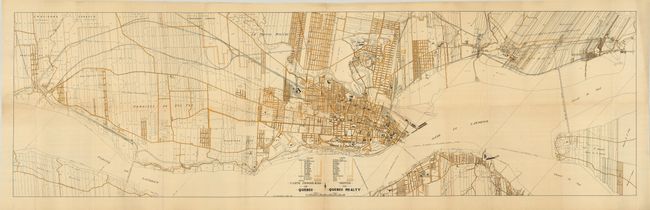
This is a large and highly detailed folding map of Quebec City and its environs. The map illustrates the extensive plans for development of the area surrounding Quebec. The city plan shows all streets, important buildings and parks and the legend names and locates 13 city wards. Outside the city, overprinted lines delineate the named Parishes. The map extends west to Queen City and eastward to beyond Courville and Beauport Village. The "Aero Shed" on the Exposition grounds must be an early airport or aerodrome. The title is given in French and English. No references located and the only example we find is in OCLC (Online Computer Library Center, Inc.).
References:
Condition: B+
Folding as issued. With a hint of fold toning and a couple fold intersections splits.