Subject: Western Hemisphere
Period: 1660 (circa)
Publication:
Color: Hand Color
Size:
19.5 x 14.8 inches
49.5 x 37.6 cm
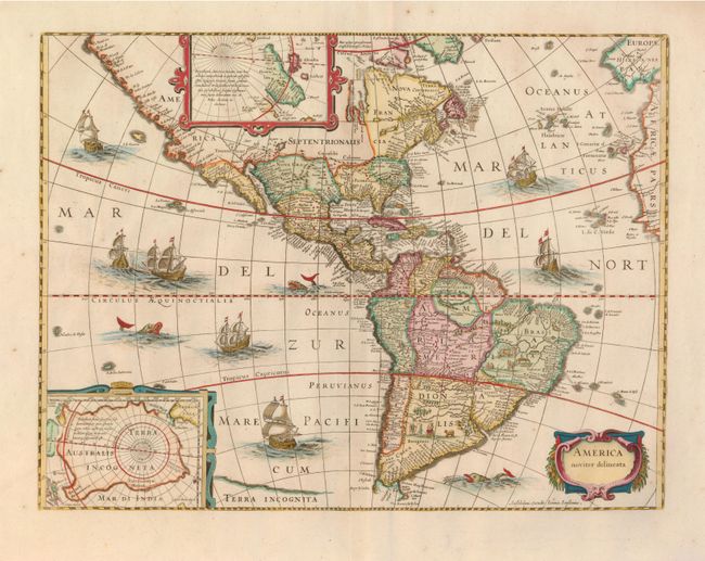
This beautiful and popular map of the Americas was emulated by many cartographers and went through numerous editions. Originally issued by Jodocus Hondius in 1618 with carte-a-figures borders, it was derived from two earlier maps by Blaeu. The North Pole depicts Frobisher's theory of the Northwest Passage and the South Pole shows the long-held notion of the mythical southern continent. North America retains the peninsular California and the East Coast is beginning to take shape, although it still lacks detail in the mid-Atlantic region. In the Southwest the famous seven cities of Cibola appear on the banks of a large lake. In South America, the fictional Parime Lacus lies on the Equator, and there are tiny engraved scenes, one detailing a cannibalistic feast. Two stylized insets of the polar regions are enclosed in strapwork cartouches. The map is richly ornamented with a strapwork title cartouche, fleets of ships and sea monsters.
Shortly after Jodocus Hondius' death in 1629 the plated passed into the hands of his brother, Henricus. The borders were removed to facilitate the smaller format of the Atlas Novus that was published in partnership with his brother-in-law, Jan Jansson. This is state 5 with Jansson's imprint below the cartouche. Blank verso.
References: Burden #192; Tooley (Amer) plt. 172.
Condition: A
Very wide margins with a couple minor tears repaired and tissue reinforcement along the centerfold.