Antique Maps, Charts, Atlases and Globes for Sale at Auction

Old World Auctions - Antique Map Specialists


Antique Map Auction Sale No. 124 - closed 5/7/2008

Featuring 801 lots of rare antique maps, charts, pocket maps, globes and atlases
Prices Realized       Table of Contents       Search Auction


Lot #712: 
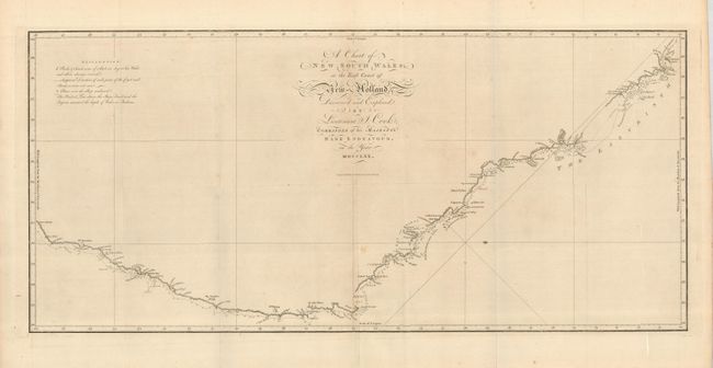
"A Chart of New South Wales, or the East Coast of New Holland. Discovered and Explored by Lieutenant J. Cook, Commander of his Majesty's Bark Endeavor, in the Year MDCCLXX" Capt. James Cook

Antique map chart A Chart of New South Wales or the East Coast of New
Click to see full size image(s)

Estimate:
$1,300.00 - $1,600.00
Sold for: $1,600.00

Lot 712
By: Capt. James Cook
Subject: Australia
Date: 1773

Publication: Account of the Voyages Undertaken ... in the Southern Ocean

Condition: B+
See Condition Guidelines

Color: uncolored

Size: 30.8 x 14.3 inches
78.3 x 36.4 cm

This is the first published chart of the east coast of Australia from Captain James Cook's first Pacific voyage in1768-71. The map shows the routes of the Endeavor with names bestowed by Cook, including Botany Bay, which was named for the large quantities of plants located there. The chart is oriented with north to the right by a delicate fleur-de-lis and soundings are located along the route. Engraved by W. Whitchurch and published by James Hawksworth.

A sound example with folds as issued, and one intersectional separation reinforced on the verso with tissue. There is a faint spot in the lower part of the map.


Ref: Tooley (MCC-64) #325.

Search this archived auction | Antique Map Price Guide