Subject: North America
Period: 1857 (dated)
Publication:
Color: Hand Color
Size:
63 x 65 inches
160 x 165.1 cm
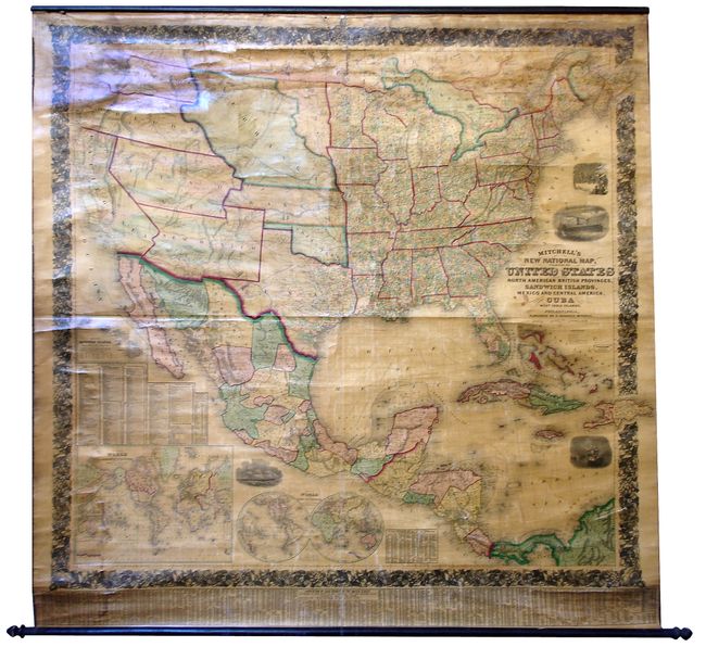
A truly beautiful example of Mitchell's "New" map of the United States in North America. The map shows the entire United States featuring early territorial borders in the West. Washington and Oregon extend to Nebraska Territory at the Continental Divide. Along the Canadian boundary, Nebraska Territory continues eastward to the Missouri River where it joins a small unnamed region west of Minnesota labeled "Plateau du Cotaeu do Missouri." The huge territory of Utah stretches between California eastward to Nebraska and Kansas. New Mexico Territory includes all of present day Arizona, the southern tip of Nevada, and a small portion of Colorado. Finally, the oversized Kansas Territory shares its western border with Utah. Large inset maps depict the Sandwich Islands, the world on Mercator's Projection, and the world in hemispheres. Several finely engraved vignettes include the "Clipper Ship Flying Cloud" and an "American Steamship Crossing the Atlantic." The map is very detailed with hundreds of place names, plus roads, villages, railroads, ports, etc. A table at bottom gives the 1850 population for many U.S. cities; a small table gives the population of numerous Canadian cities from the 1851 census. All surrounded by a wide decorative border. This is an exceptional example of Mitchell's wall map that is in remarkable original condition, complete with both original rollers present and attached.
References:
Condition: B+
Bright coloring and strong impression, varnish mostly clear and bright, just a little yellow toning. Hint of water stains at left corners. Surface is mostly unblemished with some cracking evident at upper edge near roller. The original green cloth edge binding at both sides is still mostly present. There is some modern linen added to reinforce portions of the original linen. Overall an exceptional example.