Catalog Archive
Auction 123, Lot 249

"Official Map of the Territory of Dakota, Showing the Two General Divisions of Dakota, South and North, the Land Districts, Indian Reservations, Counties, Towns and Railroads.", Rand McNally & Co.

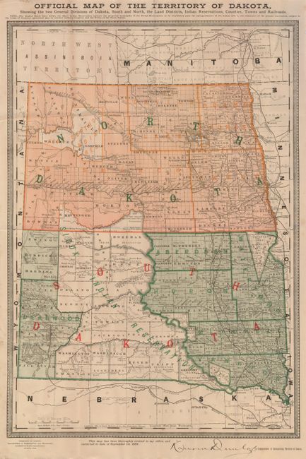
Subject: Dakota Territory

Period: 1885 (dated)

Publication:

Color: Printed Color

Size:
13.3 x 19.2 inches
33.8 x 48.8 cm
Download High Resolution Image
(or just click on image to launch the Zoom viewer)

Attractive and very detailed map showing the territory already divided into north and south. This uncommon map illustrates counties, cities, towns, railroads, watershed, topography, forts and more. A thin strip of land on the Sioux Indian reservation, between Schnasse County and Dewey and Bozeman Counties is labeled as "not in any county". The Northern & Pacific Railroad bisects North Dakota from Fargo to Sentinel Butte, and identifies many stops along the way, including Bismarck and Mandan. A note in the bottom margin states: "This map has been thoroughly revised in my office, and corrected to date of September 1st, 1885.", and bears the printed signature of Lauren Dunlap, Commissioner of Immigration, Territory of Dakota.

References:

Condition: B+

Folded, as issued with some extraneous creases. A few, small paper repairs on verso to close fold intersection splits.

Estimate: $150 - $250

Sold for: $110

Closed on 2/20/2008

Archived